 Filter: Categories of Wisconsin Historical Images
Filter: Subject of Canoes and canoeing
Filter: Subject of michigan, lake
Filter: Categories of Wisconsin Historical Images
Filter: Subject of Canoes and canoeing
Filter: Subject of michigan, lake

| Date: | 1925 |
|---|---|
| Description: | This map shows state trunk highways, county trunk highways, railroads, canoe trails, lakes, and free public camp sites. The map on the reverse also shows a... |
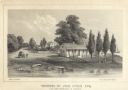
| Date: | 1856 |
|---|---|
| Description: | Lithograhic view of the residence of John Kinzie on the bank of the Chicago River at the mouth of Lake Michigan. The residence consists of a house with a f... |

| Date: | 2005 |
|---|---|
| Description: | This map shows dams and falls, areas of portage, canoe and kayak access, boat launches, parking, restrooms, picnic areas, dining, rapid water, parks, and b... |

| Date: | 1921 |
|---|---|
| Description: | This map shows in red the NorthWestern Railway Line routes running from Chicago, Illinois to northern Wisconsin and Michigan. The map includes cities and t... |

| Date: | 1922 |
|---|---|
| Description: | This map shows in red the NorthWestern Railway Line routes running from Chicago, Illinois to northern Wisconsin. The map includes cities and towns, lakes, ... |

| Date: | 1783 |
|---|---|
| Description: | Map of eastern Canada and part of America, with an inset map of the Great Lakes region in the lower left corner. It shows boundaries, cities, settlements, ... |
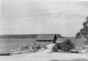
| Date: | 1935 |
|---|---|
| Description: | Canoes and small sailboats are pulled up on the shore or tied up to the piers extending from the wharf at Ellison Bay. There is a small warehouse on the wh... |

| Date: | |
|---|---|
| Description: | Map showing the location of the Little Bohemia lodge and restaurant, with major routes from Chicago and eastern and central Wisconsin. |
If you didn't find the material you searched for, our Library Reference Staff can help.
Call our reference desk at 608-264-6535 or email us at: