 Filter: Categories of Wisconsin Historical Images
Filter: Subject of Canals
Filter: Subject of shipping
Filter: Categories of Wisconsin Historical Images
Filter: Subject of Canals
Filter: Subject of shipping
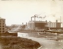
| Date: | 1900 |
|---|---|
| Description: | Southeast panorama of the McCormick Reaper Works, rail yard and canal. The factory was owned by the McCormick Harvesting Machine company before 1902. In 19... |
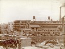
| Date: | 1900 |
|---|---|
| Description: | Workers loading and unloading wood at the wood stock yard of the McCormick Reaper Works. Men are working on both sides of the Chicago River. Rail cars and ... |

| Date: | 1873 |
|---|---|
| Description: | Engraved image of a lock and dam at Sault St. Marie. Two men are operating the sluice as ships are waiting on the opposite side of the lock. Another man is... |

| Date: | 1872 |
|---|---|
| Description: | This 1872 map shows the proposed route of a canal between Sturgeon Bay, on the Green Bay side of the Door Peninsula, and Lake Michigan. Depths in both Stur... |

| Date: | 1902 |
|---|---|
| Description: | This map is a chart of Milwaukee Harbor that displays local streets, bridges, roads, railroads, public buildings, businesses, factories, dry docks, parks, ... |
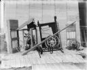
| Date: | 1900 |
|---|---|
| Description: | Corn binder dismantled for shipping. Some parts are crated. There is a white sheet behind the corn binder serving as a backdrop, and railroad tracks run al... |
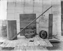
| Date: | 1900 |
|---|---|
| Description: | Binder dismantled for shipping. There is a white sheet behind the crates serving as a backdrop. In the background on the left are railroad tracks running a... |

| Date: | 1923 |
|---|---|
| Description: | This map includes an explanation that reads: "This chart shows the movement of barley on the Great Lakes, St. Lawrence River, and New York State Barge Cana... |

| Date: | 1923 |
|---|---|
| Description: | This map includes an explanation that reads: "This chart shows the movement of corn on the Great Lakes, St. Lawrence River, and New York State Barge Canal ... |

| Date: | 1923 |
|---|---|
| Description: | This map includes an explanation that reads: "This chart shows the easterly movement of flaxseed on the Great Lakes, St. Lawrence River, and New York State... |

| Date: | 1923 |
|---|---|
| Description: | This map includes an explanation that reads: "This chart shows the movement of grain on the Great Lakes, St. Lawrence River, and New York State Barge Canal... |

| Date: | 1923 |
|---|---|
| Description: | This map includes an explanation that reads: "This chart shows the movement of rye on the Great Lakes, St. Lawrence River, and New York State Barge Canal d... |

| Date: | 04 1926 |
|---|---|
| Description: | This blueprint mostly shows various numbers within the canal and bay. Lake Michigan and Harobor of Refuge are shown along the far right side. Near the harb... |

| Date: | 1868 |
|---|---|
| Description: | This map includes a table of estimated costs "by Brev. Maj. Gen. G.K. Warren Maj. U.S.E., of improvement of Wis. River from his survey of 1867." Included a... |
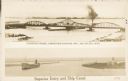
| Date: | 1907 |
|---|---|
| Description: | Postcard with two images. The top text reads: "Interstate Bridge, connecting Superior, Wis. and Duluth, Minn." The bottom text reads: "Superior Entry and S... |
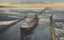
| Date: | 06 14 1947 |
|---|---|
| Description: | Text on front reads: "Opening of Navigation Season, First Giant Freighters Entering Ship Canal and Duluth-Superior Harbor." On reverse: "The navigation sea... |
If you didn't find the material you searched for, our Library Reference Staff can help.
Call our reference desk at 608-264-6535 or email us at: