 Filter: Categories of Wisconsin Historical Images
Filter: Subject of Canals
Filter: Community of Sturgeon Bay
Filter: Categories of Wisconsin Historical Images
Filter: Subject of Canals
Filter: Community of Sturgeon Bay

| Date: | 1953 |
|---|---|
| Description: | View across water towards the Sturgeon Bay Canal Lighthouse, with a group of people in a motorboat in the foreground. |

| Date: | 1875 |
|---|---|
| Description: | The harbor piers and the entrance to the Sturgeon Bay ship canal. Men are standing on the shoreline. |
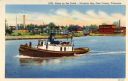
| Date: | 1940 |
|---|---|
| Description: | Canal scene with a tugboat featured in the foreground and buildings on the opposite shoreline. Caption reads: "Scene on the Canal — Sturgeon Bay, Door Coun... |

| Date: | 1915 |
|---|---|
| Description: | View of the Sturgeon Bay ship canal. Caption reads: "Sturgeon Bay Ship Canal." |

| Date: | 1913 |
|---|---|
| Description: | View of the canal. Caption reads: "The Canal, Stugeon[sic] Bay, Wis." |
| Date: | |
|---|---|
| Description: | View of the bridge spanning the Sturgeon Bay canal. |
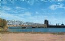
| Date: | |
|---|---|
| Description: | View from the shoreline of a bridge spanning the Sturgeon Bay canal. |

| Date: | 1872 |
|---|---|
| Description: | This 1872 map shows the proposed route of a canal between Sturgeon Bay, on the Green Bay side of the Door Peninsula, and Lake Michigan. Depths in both Stur... |

| Date: | 1906 |
|---|---|
| Description: | Hand-colored postcard view of the Sturgeon Bay ship canal from the bay toward shore. A sailboat is on the left and a lighthouse is on shore on the right. C... |

| Date: | 1950 |
|---|---|
| Description: | This map of Sturgeon Bay is part of the survey of the northern and northwestern lakes. The map shows lights, railroads, roads, and some public buildings. R... |

| Date: | 06 25 1901 |
|---|---|
| Description: | This map shows beacons, buoys, docks, quarries, streets, and buildings. The map inset shows the Harbor of refuge at entrance to Sturgeon Bay and Lake Michi... |

| Date: | 12 28 1908 |
|---|---|
| Description: | This map shows beacons, buildings, streets, and quarries. Two inset maps include: Vicinity of Sturgeon Bay, Wis. and the Harbor of refuge at entrance to St... |

| Date: | 01 06 1958 |
|---|---|
| Description: | View from jetty out towards Lake Michigan entrance to Ship Canal. A large tank, streetlamp and buildings are on the left. On the opposite jetty is a lighth... |

| Date: | 01 06 1958 |
|---|---|
| Description: | View of the Ship Canal from the Coast Guard station. There are pieces of machinery on the right, and a line of trees on the left. There is snow on the grou... |
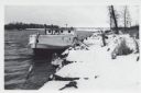
| Date: | 01 06 1958 |
|---|---|
| Description: | View from snowy shoreline of Mooring Basin at bay end of Ship Canal. The boat moored in the foreground is named "Allie." It is tethered to a post on the sh... |

| Date: | 04 1926 |
|---|---|
| Description: | This blueprint mostly shows various numbers within the canal and bay. Lake Michigan and Harobor of Refuge are shown along the far right side. Near the harb... |
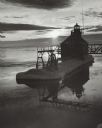
| Date: | 03 1969 |
|---|---|
| Description: | The Sturgeon Bay Ship Canal Pierhead Lighthouse silhouetted against the sun shining through the clouds. Snow covers the pier, and ice is floating on the la... |
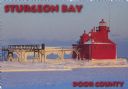
| Date: | 1963 |
|---|---|
| Description: | Text on front reads: "Sturgeon Bay, Door County." On reverse: "Sturgeon Bay, Wisconsin, Door County. North Pierhead Light. Winter shows its pretty face on ... |

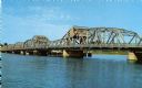
| Date: | 1935 |
|---|---|
| Description: | Text on front reads: "Bridge at Sturgeon Bay, Door County, Wisconsin." This bridge, also known as the Michigan Street Bridge, was built in 1929 and opened ... |

| Date: | 07 06 1931 |
|---|---|
| Description: | Text on front reads: "Where Green Bay and Sturgeon Bay Meet, Sturgeon Bay, Wis." Aerial view of Sturgeon Bay showing the only bridge in existence at the ti... |
If you didn't find the material you searched for, our Library Reference Staff can help.
Call our reference desk at 608-264-6535 or email us at: