 Filter: Categories of Wisconsin Historical Images
Filter: Subject of Canals
Filter: Type of Map or Atlas
Filter: Categories of Wisconsin Historical Images
Filter: Subject of Canals
Filter: Type of Map or Atlas

| Date: | 1872 |
|---|---|
| Description: | Birds-eye drawing of Eau Claire depicts street names and street locations, houses, trees, bridges, piers, canals, railroads, and the Chippewa and Eau Clair... |

| Date: | 1892 |
|---|---|
| Description: | Bird's-eye map of Princeton, with an inset of the Residence of F.T. Yahr. Fox River loops to left of center, with one bridge; thirty-six businesses, reside... |

| Date: | |
|---|---|
| Description: | Plat map of the east central part of the city. |
| Date: | 1849 |
|---|---|
| Description: | Map reads, "Map of the Western States". Published by Ensign & Thayer. There is a decorative vine border, and in each corner there is an engraving of four c... |

| Date: | 1839 |
|---|---|
| Description: | Map of a canal route to avoid the principal rapids of the Neenah or Fox River between Lake Winnebago and Green Bay. |

| Date: | 1837 |
|---|---|
| Description: | Map of the proposed route of the Milwaukee and Rock River Canal. |

| Date: | 1847 |
|---|---|
| Description: | A color map of Kentucky with insets showing Lexington, the Falls of Ohio, and the Ohio River. |

| Date: | 1878 |
|---|---|
| Description: | This map shows block numbers, wards, roads, railroads, parks, and selected buildings and includes a "Milwaukee city street guide" as well as a guide to pub... |

| Date: | 1942 |
|---|---|
| Description: | This map shows the Wisconsin and Fox River routes in green, and the Milwaukee and Rock River Canal routes in red. Prairie du Chien, Fort Winnebago, Grand C... |

| Date: | 1853 |
|---|---|
| Description: | Wisconsin counties by color and shows railroads, common roads, canals, the state capital, county towns, townships, villages, and post offices, |

| Date: | 1854 |
|---|---|
| Description: | Map of the whole state Wisconsin includes an inset of the vicinity of Milwaukee, which shows the boundaries for Lisbon, Menomonee, Pewaukee, Brookfield, Wa... |

| Date: | 1857 |
|---|---|
| Description: | This detailed map was drawn nearly a decade after Wisconsin entered statehood. It depicts the entire state, northern Illinois and part of the upper peninsu... |

| Date: | 1847 |
|---|---|
| Description: | A hand-colored map that shows the area south and east of the Wisconsin and Fox Rivers, as well as a few landmarks just north of that area. The township gri... |

| Date: | 1839 |
|---|---|
| Description: | This map shows the township and section grid, lakes, rivers, swamps, prairies, roads, and proposed canals in the area of Wisconsin south of Lake Winnebago ... |

| Date: | 1839 |
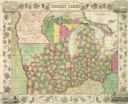
|---|---|
| Description: | Wisconsin was considered part of Michigan Territory until 1836, a year before Michigan entered statehood. Drawn in 1839, this map shows the state of Michig... |

| Date: | 1840 |
|---|---|
| Description: | This hand-colored map shows the township and section grid in southeastern Wisconsin, covering the area west to Sugar River and Four Lakes region and north ... |

| Date: | 1844 |
|---|---|
| Description: | Wisconsin was considered part of Michigan Territory until 1836, a year before Michigan entered statehood. Drawn four years before Wisconsin entered stateho... |

| Date: | 1845 |
|---|---|
| Description: | Wisconsin was considered part of Michigan Territory until 1836, a year before Michigan entered statehood. Drawn three years before Wisconsin entered stateh... |
If you didn't find the material you searched for, our Library Reference Staff can help.
Call our reference desk at 608-264-6535 or email us at:

