 Filter: Categories of Wisconsin Historical Images
Filter: Subject of Camps
Filter: Year of 1900-1999
Filter: Year of 1920-1929
Filter: Categories of Wisconsin Historical Images
Filter: Subject of Camps
Filter: Year of 1900-1999
Filter: Year of 1920-1929
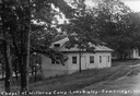
| Date: | 1926 |
|---|---|
| Description: | Caption reads: "Chapel at Willerup Camp — Lake Ripley — Cambrdige. Wis." The camp was named for the Danish immigrant minister, Christian B. Willerup, who e... |
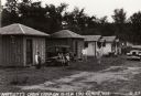
| Date: | 1929 |
|---|---|
| Description: | Bartlett's Cabin Camp on Highways 10 &12 near Eau Claire. |

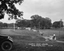
| Date: | 1925 |
|---|---|
| Description: | The Olin Park tourist campground on the shore of Lake Monona in Madison. |
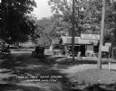
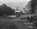
| Date: | 1925 |
|---|---|
| Description: | The free tourist campground in Baraboo. Although similar free facilities were clustered in resort areas, by 1926 the Highway Commission engineer could rep... |
| Date: | 1925 |
|---|---|
| Description: | Free public campground at Baraboo, one of 200 such facilities then made available to the traveling public by Wisconsin municipalities. |
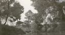
| Date: | 1920 |
|---|---|
| Description: | View across water towards the C.R. Pickering Camp on Mill Creek, in summer. The shelter is on a hill overlooking the pond. |
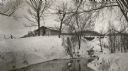
| Date: | 1920 |
|---|---|
| Description: | C.R. Pickering Camp on Mill Creek, in winter with snow on the ground. On the opposite shoreline is a shelter on the hill overlooking the creek, with a set ... |

| Date: | 1925 |
|---|---|
| Description: | A view of the 7-acre Hallelujah Campground which was located at the corner of Janesville Street and South Perry Parkway in the Village of Oregon. According... |
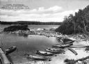
| Date: | 1925 |
|---|---|
| Description: | Elevated view of the harbor at Camp Kennington with boats pulled onto the shore of a small inlet, part of Lake Sebago. Caption reads: "The Harbor, Camp Ken... |

| Date: | 1920 |
|---|---|
| Description: | A man standing in the cook house doorway at a convict camp comprised of several tents and a iron cage on wheels. |
| Date: | 04 13 1925 |
|---|---|
| Description: | View down dirt road of people standing beneath the trees at Ottawa Park Tourist Camp. Automobiles are parked in the background, and tents are set up throug... |

| Date: | 09 01 1928 |
|---|---|
| Description: | Photographic postcard view of the Bruce Tourist Camp. A dirt road curves into the camp, with a large sign at the entrance, and cabins, picnic tables and ma... |
| Date: | 1925 |
|---|---|
| Description: | The entrance to the Carthwaite Park tourist camp and picnic grounds. There is a sign for a filling station 1 mile ahead. A car is parked inside the grounds... |
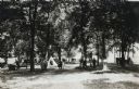
| Date: | 1924 |
|---|---|
| Description: | Looking down from a hilltop of a car parked under a tree. The campground is populated with well-dressed families walking down a path, and their parked cars... |

| Date: | 1927 |
|---|---|
| Description: | Blueprint-style map of Frost Woods on the shore of Lake Monona. The map indicates the locations of Indian mounds, an Indian camp, and various plants. There... |
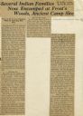
| Date: | 07 05 1928 |
|---|---|
| Description: | Article entitled "Several Indian Families Now Encamped at Frost's Woods, Ancient Camp Site" about Winnebago (Ho-Chunk) Indians camping on the shores of Lak... |
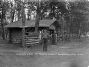
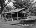
| Date: | 06 1926 |
|---|---|
| Description: | A man poses holding a fish in both hands. Two boys wait at the service window of a log cabin. |

| Date: | 1925 |
|---|---|
| Description: | This map shows state trunk highways, county trunk highways, railroads, canoe trails, lakes, and free public camp sites. The map on the reverse also shows a... |

| Date: | 1926 |
|---|---|
| Description: | This Wisconsin Conservation Commission map from the 1920s shows roads, railroads, campsites, lookout towers, and privately owned lands in Northern Forest S... |

| Date: | 1926 |
|---|---|
| Description: | This 1926 map depicts resorts and camps, lakes and streams, railroads, and roads in portions of Vilas, Iron, Oneida, Price, and Lincoln counties in Wiscons... |
If you didn't find the material you searched for, our Library Reference Staff can help.
Call our reference desk at 608-264-6535 or email us at: