 Filter: Categories of Wisconsin Historical Images
Filter: Subject of Cable cars (Streetcars)
Filter: County of Milwaukee
Filter: Subject of cable cars (streetcars)
Filter: Categories of Wisconsin Historical Images
Filter: Subject of Cable cars (Streetcars)
Filter: County of Milwaukee
Filter: Subject of cable cars (streetcars)

| Date: | |
|---|---|
| Description: | Elevated view from the top of a building looking onto the square and down East Water Street. A fountain with a monument to Henry Bergh is in the lower cent... |

| Date: | 1910 |
|---|---|
| Description: | Later renamed Locust Street, the bridge spans the Milwaukee River near Riverside Park. Elevated view from shoreline. A trolley and a pedestrian are on the ... |
| Date: | |
|---|---|
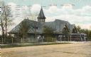
| Description: | View across road toward a large pavilion with a gray roof and tower. A dirt road passes across the lower foreground. On the right of the building is a trol... |

| Date: | |
|---|---|
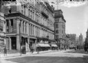
| Description: | Elevated view of the hotel on a street corner. The Majestic is the tallest building in the image. Signs designate two of the buildings, with a smaller buil... |
| Date: | 1905 |
|---|---|
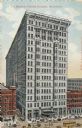
| Description: | Elevated view of fourteen-story theatre building, with two red buildings on either side of it. On the street are people, horses, carriages, and trolleys. C... |

| Date: | 1914 |
|---|---|
| Description: | Elevated view of hotel on Wisconsin Street. The hotel was opened for business in January of 1914. A flag is flying from the roof. Pedestrians are walking ... |
| Date: | 1905 |
|---|---|
| Description: | Slightly elevated view of Wisconsin Street, with the bridge on the left. Caption reads: "View east on Wisconsin Street, from Grand Avenue Buscule Bridge, M... |

| Date: | 1890 |
|---|---|
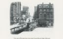
| Description: | Exterior of building, with arched main entrance. The road in front is crowded with pedestrians, trolleys, and horse-drawn vehicles. On the left is a boat ... |
| Date: | |
|---|---|
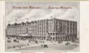
| Description: | Elevated view looking east on Grand Avenue from the corner of Grand Avenue and 2nd Street. Plankinton Block was located between West Water (now Plankinton ... |

| Date: | 1900 |
|---|---|
| Description: | Washington Monument on Grand Avenue with a streetcar coming up the street in the background. Caption reads: "Washington Monument on Grand Ave., Milwaukee." |

| Date: | 1910 |
|---|---|
| Description: | Elevated view of brewing company. A sign for Schlitz is suspended between two of the buildings. Pedestrians, trolleys, and horse-drawn vehicles are on the ... |
| Date: | |
|---|---|
| Description: | View down Milwaukee street with strolling pedestrians on the sidewalk. The large commercial buildings include the Gridley Dairy Co. storefront. There is al... |
| Date: | |
|---|---|
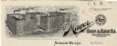
| Description: | Letterhead of the F. Mayer Boot & Shoe Company of Milwaukee, manufacturers of and dealers in footwear, with an elevated, three-quarter view of the Mayer co... |
| Date: | |
|---|---|
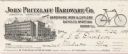
| Description: | Billhead of the John Pritzlaff Hardware Company of Milwaukee, Wisconsin, "jobbers in hardware, iron & cutlery, bicycles, sporting goods etc.," with a three... |
| Date: | |
|---|---|
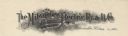
| Description: | Letterhead of the Milwaukee Electric Railway and Light Company, with a three-quarter view of a man driving an electric cable car marked "State St." under a... |
| Date: | |
|---|---|
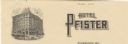
| Description: | Letterhead of the Hotel Pfister, with a three-quarter view of the building, and automobiles, a trolley car, and horse-drawn vehicles on the streets. |

| Date: | |
|---|---|
| Description: | Letterhead of the Langenberger Construction Company of Milwaukee, Wisconsin, with an elevated three-quarter view of the company building and traffic in the... |
| Date: | 09 1900 |
|---|---|
| Description: | View down Grand Avenue. Near a streetcar is the city's Civil War memorial, erected in 1898 by John Conway. |

| Date: | 1906 |
|---|---|
| Description: | This map shows ward boundaries, subdivisions, lot and block numbers and dimensions, house numbers, electric car lines, steam railways, and adjoining plat n... |

| Date: | 1906 |
|---|---|
| Description: | This map shows ward boundaries, lot and block numbers and dimensions, house numbers, electric car lines, steam railways, and adjoining plat numbers in a po... |
If you didn't find the material you searched for, our Library Reference Staff can help.
Call our reference desk at 608-264-6535 or email us at: