 Filter: Categories of Wisconsin Historical Images
Filter: Subject of Cable cars (Streetcars)
Filter: County of Milwaukee
Filter: Creator Name of C.N. Caspar Company
Filter: Categories of Wisconsin Historical Images
Filter: Subject of Cable cars (Streetcars)
Filter: County of Milwaukee
Filter: Creator Name of C.N. Caspar Company
| Date: | |
|---|---|
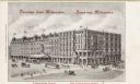
| Description: | Elevated view looking east on Grand Avenue from the corner of Grand Avenue and 2nd Street. Plankinton Block was located between West Water (now Plankinton ... |

| Date: | 1906 |
|---|---|
| Description: | This map shows ward boundaries, lot and block numbers and dimensions, house numbers, electric car lines, steam railways, and adjoining plat numbers in a po... |
If you didn't find the material you searched for, our Library Reference Staff can help.
Call our reference desk at 608-264-6535 or email us at: