 Filter: Categories of Wisconsin Historical Images
Filter: Subject of Business
Filter: Subject of human settlements
Filter: Year of 1900-1999
Filter: Categories of Wisconsin Historical Images
Filter: Subject of Business
Filter: Subject of human settlements
Filter: Year of 1900-1999

| Date: | 1987 |
|---|---|
| Description: | This pictorial map shows roads, bridges, local businesses with phone numbers, and public buildings. Relief is shown pictorially. Also included is a calen... |

| Date: | 1968 |
|---|---|
| Description: | Three maps that show local streets, roads, railroads, parks, country clubs, the University of Wisconsin, Shorewood Hills, Maple Bluff, Monona, Truax Field,... |

| Date: | 1962 |
|---|---|
| Description: | This blue print map shows 5 zoning districts, as well as lot and block numbers and dimensions, public land, streets, and Mill Pond. The zones are: "Single ... |

| Date: | 11 21 1950 |
|---|---|
| Description: | This map shows agricultural, residence, business, and industrial districts as well as lot and block numbers. |

| Date: | 1903 |
|---|---|
| Description: | This blue line print map is oriented with the north to the left and shows buildings with dimensions, utilities, and proposed buildings. The Flambeau River ... |

| Date: | 1960 |
|---|---|
| Description: | This dot density map shows the number of shipments in 1952 throughout Wisconsin and to other United States destinations from Neillsville. Mellen, Cable, Bl... |

| Date: | 1990 |
|---|---|
| Description: | This map shows various types of trails, boat landings, canoe areas, public beaches, picnic areas, campgrounds, golf courses, public tennis courts, and othe... |

| Date: | 1980 |
|---|---|
| Description: | This map shows the locations of 42 businesses, roads, points of interest, recreation sites, camping, the North Country Trail and parking, and boundaries of... |

| Date: | 1914 |
|---|---|
| Description: | This photostat map shows Fort Winnebago around 1931, land to be reserved for military purposes, roads to Fort Howard and Fort Crawford, "private property" ... |

| Date: | 1900 |
|---|---|
| Description: | This map shows landownership, churches, schools, farm houses, wagon roads, railroads, and townships and includes businesses advertisements, tables of stati... |
| Date: | 1922 |
|---|---|
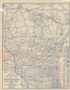
| Description: | This map shows roads, highways, lakes, rivers, county boundaries, and cities. Selected businesses are highlighted in red. Includes an explanation of state ... |

| Date: | 1900 |
|---|---|
| Description: | This photocopy map shows blocks, lots, subdivisions, city wards, buildings, some landownership, and the Mississippi River. The map margins include business... |

| Date: | 1918 |
|---|---|
| Description: | Poster featuring a cartoon panel showing a busy town, with several shops labeled: "Toys, Dry Goods, Hats, Shoes, Clothes, Prosperity Shop, and Drug Store."... |

| Date: | 1918 |
|---|---|
| Description: | Poster featuring a cartoon illustration of a monumental hand reaching out of the clouds and down towards a town. The town includes an Army Camp, The Home, ... |

| Date: | 1918 |
|---|---|
| Description: | Poster featuring a cartoon illustration of two men meeting in "Plot Alley." One or both men are saying: "You're all right!" One man is wearing a suit label... |

| Date: | 1918 |
|---|---|
| Description: | Poster with red text overlaying illustrations in blue. The top left illustration is of soldiers with cannons on battlefront. At the bottom right is an illu... |

| Date: | 1914 |
|---|---|
| Description: | Twelve photographs and one letterhead are mounted on a board with captions. The photographs cover the time before and after a fire in 1909 when the company... |
If you didn't find the material you searched for, our Library Reference Staff can help.
Call our reference desk at 608-264-6535 or email us at: