 Filter: Categories of Wisconsin Historical Images
Filter: Subject of Bridges
Filter: Year of 1800-1899
Filter: Categories of Wisconsin Historical Images
Filter: Subject of Bridges
Filter: Year of 1800-1899

| Date: | 1893 |
|---|---|
| Description: | View of the canal area of the Columbian Exposition grounds looking north from near the front of the Machinery building (at left). The South canal is in the... |
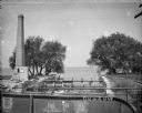
| Date: | 1895 |
|---|---|
| Description: | View from bridge towards a tall smokestack standing on the left side of the Yahara River where it is flowing out of Lake Mendota. Remnants of the foundatio... |

| Date: | 1883 |
|---|---|
| Description: | Bird's-eye view of Montello, county seat of Marquette County. The granite quarry, woolen mill, and planing mill are clearly identified. A steamboat on Buf... |
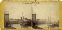
| Date: | 1870 |
|---|---|
| Description: | View of a lumber hooker ship at dock on the Root River. The 4th St. bridge spans the river at center. The Racine Woolen Mill is visible at right behind the... |

| Date: | 1862 |
|---|---|
| Description: | This detailed map shows batteries and rifle pits, railroads, common and military roads, turnpikes, city streets and names, bridges, ferries, rural houses a... |
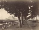
| Date: | 1890 |
|---|---|
| Description: | View down road lined with trees in Egypt. A group of Egyptians are standing and sitting between the trees and the river, and travelers on the road are walk... |

| Date: | 1856 |
|---|---|
| Description: | ". . . The upper Grand Chute was the last of the 'improvements' paintings signed by Brookes and Stevenson. Yet there were two more vital links in the Fox R... |

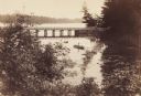
| Date: | 1891 |
|---|---|
| Description: | A deeply rutted dirt road leads to a bridge over a river. Buildings are on both sides of the river. Bluffs and hills with trees are in the background. This... |

| Date: | 09 27 1895 |
|---|---|
| Description: | Elevated view of men and horses standing atop the platform used to load wood into charcoal kilns, also known as pits. These kilns convert cord wood into ch... |

| Date: | 1873 |
|---|---|
| Description: | A map that covers parts of Winona and Houston Counties, Minnesota and La Crosse County, Wisconsin, showing the proposed railroad routes, constructed rail l... |

| Date: | 1897 |
|---|---|
| Description: | This 1897 map of Sawyer County, Wisconsin, shows the township and range system, sections, roads, farm houses, camps, school houses, dams, bridges, Indian r... |

| Date: | 1800 |
|---|---|
| Description: | This pen and ink drawing with watercolor shows the course of the Black River from Rock Creek, near Greenwood in Clark County, Wisconsin, to its confluence ... |

| Date: | 1893 |
|---|---|
| Description: | Bird’s-eye view of Depere looking North. Includes illustrations and an index to points of interest. |

| Date: | 1831 |
|---|---|
| Description: | Map of the city of Louisville, Kentucky on the Ohio River showing streets and numbered lots. The Ohio River, Corn Island, and the Louisville and Portland C... |

| Date: | 1874 |
|---|---|
| Description: | Bird's-eye view map of Appleton, Wisconsin. Map reads: "NOTE.-Since the above cut was engraved, the Fox River Pulp & Paper Co.'s Mammoth Mills have been er... |

| Date: | 1875 |
|---|---|
| Description: | Elevated view over De Pere. In the foreground is the De Pere News Office and Post Office building. Behind it people are walking on the bridge over the Fox ... |
| Date: | 1889 |
|---|---|
| Description: | View from shoreline looking down on Mud Creek, about two miles above De Pere, showing small bridge and a man in a rowboat. |

| Date: | 1878 |
|---|---|
| Description: | View down Rock River towards a covered bridge near another bridge, with factories and the city in the background. |

| Date: | 1885 |
|---|---|
| Description: | A detail of a Sanborn map including Catfish Creek and Westport Road by Lake Mendota. |

| Date: | 1872 |
|---|---|
| Description: | This map is pencil, ink, and watercolor on paper. Shown on the map is the elevation and profile of La Crescent Bottoms, Mt. Vernon Street line, 13th Street... |
If you didn't find the material you searched for, our Library Reference Staff can help.
Call our reference desk at 608-264-6535 or email us at: