 Filter: Categories of Wisconsin Historical Images
Filter: Subject of Bridges
Filter: Subject of botany
Filter: Categories of Wisconsin Historical Images
Filter: Subject of Bridges
Filter: Subject of botany
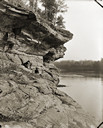
| Date: | 1900 |
|---|---|
| Description: | View along rockface shoreline towards a woman and two children sitting on Angel Rock. Along a cliff along the opposite shoreline are buildings and a bridge... |

| Date: | 1867 |
|---|---|
| Description: | Birds-eye drawing of Appleton, Outagamie Co., depicting street names and street layout, houses, the Fox River, the court house, jail, school houses, Lawren... |
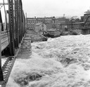
| Date: | 1916 |
|---|---|
| Description: | Water churns under a railroad bridge as the spring thaw swells the Wisconsin River. |
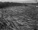
| Date: | 1895 |
|---|---|
| Description: | Logs move down the river, swirling with cross currents, resulting in a huge log jam. |

| Date: | 05 31 1965 |
|---|---|
| Description: | Elevated view of Evangelical United Brethren church in the vicinity of Highway T. |
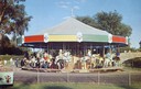
| Date: | |
|---|---|
| Description: | Children riding the carousel (merry-go-round) at Henry Vilas Zoo (Vilas Park Zoo), donated by the citizens of the Madison area. A stone bridge is in the ba... |
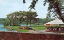
| Date: | |
|---|---|
| Description: | View from a stone bridge towards Vilas Park, with children riding the carousel (merry-go-round) and a kiddie train adjacent to the lagoon. |
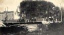
| Date: | 1904 |
|---|---|
| Description: | View across Yahara River towards a group of people on the Sherman Avenue Bridge, with the old malt house in the background. |

| Date: | 1868 |
|---|---|
| Description: | This 1868 birds-eye view depicts the buildings, streets, railroad, vegetation and topography of Columbus, Wisconsin. The high school, cemetery, railroad de... |

| Date: | 1884 |
|---|---|
| Description: | Bird's-eye map of Delavan with inset of the State Institute for Deaf and Dumb. |

| Date: | 1867 |
|---|---|
| Description: | Bird's-eye map of Green Bay and Fort Howard, Brown Co., depicts street names and street layouts, houses, trees, and the East River. A reference key at the ... |

| Date: | 1867 |
|---|---|
| Description: | Bird's-eye map of La Crosse with nine insets of residences, schools, and the Court House and Jail. |

| Date: | 1882 |
|---|---|
| Description: | Bird's-eye views of various sections of Milwaukee. |

| Date: | 1885 |
|---|---|
| Description: | Bird's-eye map of Oconomowoc. |
| Date: | 1896 |
|---|---|
| Description: | Back cover of an advertising catalog for the Milwaukee Harvester Company. The cover features a color chromolithograph illustration of young boys racing hom... |

| Date: | 1870 |
|---|---|
| Description: | Bird's-eye map of Prairie du Sac. |

| Date: | 1870 |
|---|---|
| Description: | Sauk City is the oldest incorporated village in Wisconsin (incorporated in 1854) and also has the oldest organized volunteer fire department in the state, ... |

| Date: | 1882 |
|---|---|
| Description: | This map of Cedarburg is a bird's-eye map with an inset of Cedarburg Brewery. Relief is shown pictorially and the map includes an index to buildings. |

| Date: | 1878 |
|---|---|
| Description: | Bird's-eye map of Chilton with insets of points of interest, including P.H. Becker's Brewery, Chilton House, and Gutheil's Block. |
If you didn't find the material you searched for, our Library Reference Staff can help.
Call our reference desk at 608-264-6535 or email us at:
