 Filter: Categories of Wisconsin Historical Images
Filter: Subject of Bridges
Filter: County of Ozaukee
Filter: Categories of Wisconsin Historical Images
Filter: Subject of Bridges
Filter: County of Ozaukee

| Date: | 1882 |
|---|---|
| Description: | This map of Cedarburg is a bird's-eye map with an inset of Cedarburg Brewery. Relief is shown pictorially and the map includes an index to buildings. |

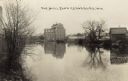
| Date: | |
|---|---|
| Description: | Photographic postcard of a mill next to Cedar Creek. There is a bridge on the right, and a factory in the background.. |

| Date: | 1913 |
|---|---|
| Description: | Hand-colored view of a footbridge crossing over Cedar Creek. A man is fishing from the bridge, and a dog is standing nearby. Two boys are sitting in the gr... |

| Date: | |
|---|---|
| Description: | Tinted view of the Planing Mill, with Cedar Creek running alongside. There is a bridge on the left. Caption reads: "Planing Mill from Park Street, Cedarbur... |
| Date: | |
|---|---|
| Description: | View of a mill from across the mill pond. |
| Date: | |
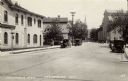
|---|---|
| Description: | View looking up Columbia Avenue, with the Merchants Bank on the left, and a mill, and a church further down on the right. Automobiles are parked along the ... |

| Date: | 1910 |
|---|---|
| Description: | View down the railroad tracks, with the depot and grain elevator on the right. A bridge is crossing a stream on the left. Caption reads: "Depot & Elevator,... |
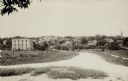
| Date: | 1916 |
|---|---|
| Description: | View of Grafton from the road leading into town. There is a bridge over the river, and a church is on the far right. Caption reads: "Birdseye [sic] View, G... |
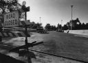
| Date: | 06 20 1985 |
|---|---|
| Description: | View of a bridge, with cars parked along the sides, and a "Road Closed" sign in the left foreground. Caption reads: "NEW BRIDGE — Work on the Falls Rd. bri... |
If you didn't find the material you searched for, our Library Reference Staff can help.
Call our reference desk at 608-264-6535 or email us at: