 Filter: Categories of Wisconsin Historical Images
Filter: Subject of Breweries
Filter: Year of 1800-1899
Filter: Year of 1880-1889
Filter: Categories of Wisconsin Historical Images
Filter: Subject of Breweries
Filter: Year of 1800-1899
Filter: Year of 1880-1889
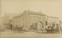
| Date: | 1885 |
|---|---|
| Description: | Exterior view of Fauerbach's Brewery at 651-53 Williamson Street. |

| Date: | 1884 |
|---|---|
| Description: | A sign for Fauerbach's Brewery depicting a young woman and the brewery. |
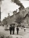
| Date: | 1888 |
|---|---|
| Description: | Exterior of Schlitz Brewing Company with two men and a boy in suits and hats in the foreground. |

| Date: | 1882 |
|---|---|
| Description: | This map of Cedarburg is a bird's-eye map with an inset of Cedarburg Brewery. Relief is shown pictorially and the map includes an index to buildings. |

| Date: | 1880 |
|---|---|
| Description: | Bird's-eye map over the Mississippi River of Fountain City. Paddle steamers and steamboats are on the river, and bluffs are in the background. |
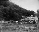
| Date: | 1880 |
|---|---|
| Description: | Exterior view of the Haertel Brewery which later became the Eulberg Brewery. |
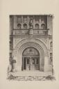
| Date: | 07 03 1886 |
|---|---|
| Description: | The ornate entrance to the Schlitz Palm Garden. Located on N. 3rd Street, south of W. Wisconsin Avenue, the Schlitz Palm Garden opened on July 3, 1886 and ... |
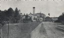
| Date: | 1880 |
|---|---|
| Description: | The brewery was built by George Schweickhart after he came to the city in 1856. He purchased three acres of land on the then Watertown Plank road, now just... |
| Date: | 1886 |
|---|---|
| Description: | Exterior view of the Potosi Brewery at about the time Adam Schumacher took over the operation. Children and adults can be seen near a fence and in horse-dr... |
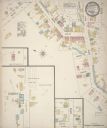
| Date: | 1884 |
|---|---|
| Description: | Sanborn map showing the main street of Potosi, Wisconsin, with an inset for the Potosi Brewery. |

| Date: | 09 1884 |
|---|---|
| Description: | Sanborn map of Fort Atkinson including Barrie, Germany, and North Water Streets. |
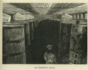
| Date: | 1885 |
|---|---|
| Description: | Engraved image of two men working in a cellar full of wooden barrels filled with fermenting beer. |
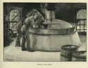
| Date: | 1885 |
|---|---|
| Description: | Engraved image of a man adding ingredients from a barrel to a boiling vat of beer. |
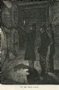
| Date: | 1880 |
|---|---|
| Description: | Engraved image of three men in a dark room examining kegs of beer by candlelight. |

| Date: | 1885 |
|---|---|
| Description: | A detail of a Sanborn map including Catfish Creek and Westport Road by Lake Mendota. |

| Date: | 1886 |
|---|---|
| Description: | This map has relief shown by hachures and includes a list of plats in order of date of record, laws which vacate plats, plats not shown as upon the county ... |
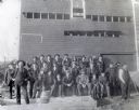
| Date: | 1886 |
|---|---|
| Description: | Outdoor group portrait of a crowd visiting Greenwood Brewery. Individuals pictured include: First row, left to right: Anton Novy, Edward McDonough, Frank R... |

| Date: | 1883 |
|---|---|
| Description: | This map shows ward boundaries, names of additions, streets, bridges, mills, schools, religious buildings, businesses, hotels, railroads, factories, brewer... |

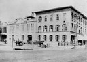
| Date: | 1883 |
|---|---|
| Description: | View across State Street towards two buildings, with, on the left, the Hess & Schmitz Livery Boarding and Sale Stable, and on the right the Empire Brewery.... |

| Date: | 10 1884 |
|---|---|
| Description: | A Sanborn map of Watertown, including the City Brewery and the Rock River. |
If you didn't find the material you searched for, our Library Reference Staff can help.
Call our reference desk at 608-264-6535 or email us at: