 Filter: Categories of Wisconsin Historical Images
Filter: Subject of Breweries
Filter: Year of 1800-1899
Filter: Subject of land
Filter: Categories of Wisconsin Historical Images
Filter: Subject of Breweries
Filter: Year of 1800-1899
Filter: Subject of land

| Date: | 1882 |
|---|---|
| Description: | This map of Cedarburg is a bird's-eye map with an inset of Cedarburg Brewery. Relief is shown pictorially and the map includes an index to buildings. |

| Date: | 1878 |
|---|---|
| Description: | Bird's-eye map of Chilton with insets of points of interest, including P.H. Becker's Brewery, Chilton House, and Gutheil's Block. |

| Date: | 1880 |
|---|---|
| Description: | Bird's-eye map over the Mississippi River of Fountain City. Paddle steamers and steamboats are on the river, and bluffs are in the background. |

| Date: | 1871 |
|---|---|
| Description: | Birds eye map of Monroe, WI, depicts street names and street locations, houses, and trees. A reference key at the bottom of the map shows the locations of ... |
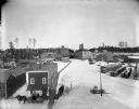
| Date: | 1895 |
|---|---|
| Description: | Buildings and grounds of the Leinenkugel Brewery. There are beer wagons in the yard, chickens along a wooden walkway, and men on a horse-drawn wagon near a... |
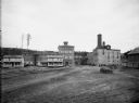
| Date: | 1876 |
|---|---|
| Description: | 462 Virginia Street. The buildings on the left are the old Melms Brewery located at the south side of the Menomonee Valley. About 1857 C.T. Melms organized... |
| Date: | 1898 |
|---|---|
| Description: | Elevated winter view of the Leinenkugel Brewery seen "from top of Mill." Originally called "Spring Brewery," Jacob Leinenkugel opened his brewery in 1867 i... |

| Date: | 09 1884 |
|---|---|
| Description: | Sanborn map of Fort Atkinson including Barrie, Germany, and North Water Streets. |

| Date: | 1870 |
|---|---|
| Description: | This 1870 map of Brown County, Wisconsin, shows the township and range grid, towns, sections, cities, villages and post offices, land ownership, roads, rai... |

| Date: | 1859 |
|---|---|
| Description: | This map show plats including plat names, plat numbers, and some lot owner's names. Relief is shown by hachures. The map includes line drawings of Juneau B... |

| Date: | 1891 |
|---|---|
| Description: | The index page of a Sanborn Map of Stevens Point. |

| Date: | 1891 |
|---|---|
| Description: | Page 13 of a Sanborn map of Stevens Point. |
If you didn't find the material you searched for, our Library Reference Staff can help.
Call our reference desk at 608-264-6535 or email us at: