 Filter: Categories of Wisconsin Historical Images
Filter: Subject of Birds
Filter: Subject of maps
Filter: Categories of Wisconsin Historical Images
Filter: Subject of Birds
Filter: Subject of maps

| Date: | 1655 |
|---|---|
| Description: | Frontispiece to Newe Welt vnd americanische Historien (1655). |

| Date: | 02 1971 |
|---|---|
| Description: | Political propaganda poster featuring a red, white, and blue eagle being struck down from the sky, accompanied by the phrase: "Strike Him Down." The eagle... |
| Date: | 1853 |
|---|---|
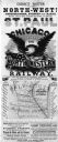
| Description: | Poster advertising Chicago & Northwestern Railway featuring a map of the route, and an image of an eagle with a banner in its beak and an American flag. |

| Date: | |
|---|---|
| Description: | Wisconsin promotional decal with a map of the state, with many cities marked and drawings of some Wisconsin icons: cheese, cows, deer, beer, Wisconsin Dell... |
| Date: | 1918 |
|---|---|
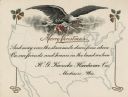
| Description: | Holiday card with the American Eagle, gripping lightening bolts, ribbons and holly in his talons. In the background are clouds and a map of the United Stat... |

| Date: | |
|---|---|
| Description: | Back, front, and inside front cover of the menu from The Restaurant at Baron's department store, with "A Historical Map of Madison" focusing on the isthmus... |
| Date: | 1952 |
|---|---|
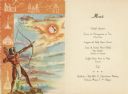
| Description: | Front cover and menu page for a banquet given by the Instituto Mexicano del Seguro Social to the senior delegates to the fourth reunion of the Inter-Americ... |
| Date: | 1894 |
|---|---|
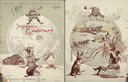
| Description: | Front cover featuring a color illustration titled: "Young Canada, 'I wonder what they are doing on the other side,'" and "Merry Christmas." A young boy wea... |

| Date: | 1958 |
|---|---|
| Description: | This map shows state public hunting and/or fishing grounds, national forests, state forests, county forests.The lower margin includes an index to these loc... |

| Date: | 1746 |
|---|---|
| Description: | This world map from the German mathematician, historian, and geographer Johann Matthias Hase shows the major cities, islands, and the major political divis... |

| Date: | 1685 |
|---|---|
| Description: | A detailed map of the western hemisphere showing cities, settlements, Native American land, rivers, lakes, mountains, the Great Lakes, and California as an... |

| Date: | 1746 |
|---|---|
| Description: | Detailed map of the western hemisphere and part of Africa and Europe. Islands, cities, settlements, rivers, lakes, countries, and regions are marked. Mount... |

| Date: | 1719 |
|---|---|
| Description: | Map of North America showing land divisions between France, Spain, England, Sweden, Denmark and Holland. The map is detailed, labeling cities, forts, islan... |

| Date: | 1766 |
|---|---|
| Description: | This map of North America shows the boundaries of European claims at the end of the French and Indian war. The British colonies extend to the Mississippi. ... |

| Date: | 1758 |
|---|---|
| Description: | Map showing lakes, rivers, cities, Native American land, and the boundaries of French and English claims in America and Canada north of New York. A title c... |

| Date: | 1720 |
|---|---|
| Description: | Detailed, ornate, and comprehensive map of America from the east coast to present day Texas. Numerous features appear throughout the map, including Native ... |
| Date: | |
|---|---|
| Description: | The Northwoods area, numbered K9GTQ, is highlighted yellow inside an outline of the shape of the state of Wisconsin. A muskie, a robin, a bear and a deer a... |

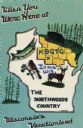
| Date: | |
|---|---|
| Description: | Map showing the location of the Little Bohemia lodge and restaurant, with major routes from Chicago and eastern and central Wisconsin. |
If you didn't find the material you searched for, our Library Reference Staff can help.
Call our reference desk at 608-264-6535 or email us at: