 Filter: Categories of Wisconsin Historical Images
Filter: Subject of Birds
Filter: Subject of great lakes
Filter: Categories of Wisconsin Historical Images
Filter: Subject of Birds
Filter: Subject of great lakes

| Date: | 1975 |
|---|---|
| Description: | This map provides an index of outdated quadrangle maps for the state. Communities, counties, rivers, and lakes are labeled including Lake Michigan and Lake... |

| Date: | 1685 |
|---|---|
| Description: | A detailed map of the western hemisphere showing cities, settlements, Native American land, rivers, lakes, mountains, the Great Lakes, and California as an... |

| Date: | 1720 |
|---|---|
| Description: | Detailed, ornate, and comprehensive map of America from the east coast to present day Texas. Numerous features appear throughout the map, including Native ... |
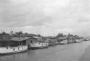
| Date: | 07 1936 |
|---|---|
| Description: | Elevated view of seagulls flying over fishing tugs moored at the wharf in Algoma. Small warehouse buildings line the wharf. Fish net drying reels are visib... |

| Date: | 1978 |
|---|---|
| Description: | Text on reverse reads: "The Seamen's Memorial Statue, Barker's Island, Superior, WI. Facing the harbor holding a massive cable is the 10 foot tall Seamen's... |
If you didn't find the material you searched for, our Library Reference Staff can help.
Call our reference desk at 608-264-6535 or email us at: