 Filter: Categories of Wisconsin Historical Images
Filter: Subject of Bird's-eye views
Filter: Subject of rivers
Filter: Categories of Wisconsin Historical Images
Filter: Subject of Bird's-eye views
Filter: Subject of rivers

| Date: | 1892 |
|---|---|
| Description: | Bird's-eye view of West Bend, looking west. Milwaukee River flows across image just below center, with fairgrounds at bottom right and Maple street at top ... |

| Date: | 1870 |
|---|---|
| Description: | Bird's-eye view of Whitewater, with insets. |

| Date: | 1881 |
|---|---|
| Description: | Bird's-eye view of Appleton. |
| Date: | 1879 |
|---|---|
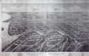
| Description: | Bird's-eye map of Beaver Dam. |
| Date: | 1942 |
|---|---|
| Description: | Trees interspersed with college buildings in lower half of image, with Fox River bisecting the middle, and a few buildings across the river with open fiel... |

| Date: | 1860 |
|---|---|
| Description: | Bird's-eye view of Janesville from the High School building. |

| Date: | 1886 |
|---|---|
| Description: | Bird's-eye view of Milwaukee from Bay View. |

| Date: | 1854 |
|---|---|
| Description: | Bird's-eye view of Milwaukee looking east toward Lake Michigan from a bluff, long since graded into a slope, at about 6th Street between Wisconsin Avenue a... |

| Date: | 1937 |
|---|---|
| Description: | Bird's-eye view of Milwaukee in 1853 details building features and city layout from southwest. Important buildings are numbered in a silhouette drawing bel... |

| Date: | 1886 |
|---|---|
| Description: | Bird's-eye map of Baraboo with inset of Devil's Lake, the south and east sides of the commercial square, the First National Bank, and the Warren House hote... |

| Date: | 1905 |
|---|---|
| Description: | Bird's-eye view of Manitowoc on the shores of Lake Michigan. A map of the northeastern part of the United States at the top indicates Manitowoc's location ... |

| Date: | 1892 |
|---|---|
| Description: | Bird's-eye view of Chicago, with ships in the Lake Michigan harbor. |

| Date: | 1892 |
|---|---|
| Description: | Bird's-eye view of the Columbian Exposition pavilions from the vantage point of Lake Michigan. Included is an inset of the Union Passenger Station (now Uni... |

| Date: | 1955 |
|---|---|
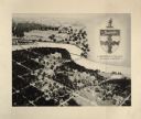
| Description: | Artist's conception of ancient village of Aztalan, fortified with high walls surrounding it. |
| Date: | 1905 |
|---|---|
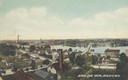
| Description: | View towards river. Caption reads: "Bird's Eye View, Beloit, Wis." |

| Date: | 1908 |
|---|---|
| Description: | Colored map in perspective indicates railroad routes. Lake Winnebago and Oshkosh in center, area extends to Shawano (top right corner), Green Bay (bottom r... |

| Date: | 1854 |
|---|---|
| Description: | Bird's-eye illustration of Milwaukee. |
If you didn't find the material you searched for, our Library Reference Staff can help.
Call our reference desk at 608-264-6535 or email us at:


