 Filter: Categories of Wisconsin Historical Images
Filter: Subject of Bird's-eye views
Filter: Subject of military art and science
Filter: Categories of Wisconsin Historical Images
Filter: Subject of Bird's-eye views
Filter: Subject of military art and science

| Date: | 1861 |
|---|---|
| Description: | Bird's-eye map of Fond du Lac, "drawn after nature," with a parade of soldiers marching down the street. |

| Date: | 1860 |
|---|---|
| Description: | Bird's-eye view of Janesville from the High School building. |

| Date: | 1862 |
|---|---|
| Description: | Birds-eye view of a Wisconsin Civil War regiment on parade in Fond du Lac, as drawn by Louis Kurz from the Marr Street Methodist Church. The regiment canno... |
| Date: | 04 05 1862 |
|---|---|
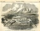
| Description: | Bird's-eye view of Camp Douglas near Chicago. Caption reads: "Camp Douglas, near Chicago, Illinois, where seven thousand rebel prisoners are quartered." |
| Date: | 08 1861 |
|---|---|
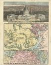
| Description: | Large-format, illustrated stationery purchased by Rudolph Fine, a member of the 6th Wisconsin Infantry in August, 1861, showing the Capitol (in actuality, ... |
| Date: | 1864 |
|---|---|
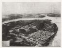
| Description: | Aerial view, probably from a lithograph, of the prison for Confederate soldiers at Rock Island. |

| Date: | 1719 |
|---|---|
| Description: | This extremely detailed and ornate map shows the cities, Native American land, mountains, lakes, rivers, and European claims of North America. An inset map... |
If you didn't find the material you searched for, our Library Reference Staff can help.
Call our reference desk at 608-264-6535 or email us at: