 Filter: Categories of Wisconsin Historical Images
Filter: Subject of Beavers
Filter: Subject of ocean
Filter: Categories of Wisconsin Historical Images
Filter: Subject of Beavers
Filter: Subject of ocean
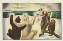
| Date: | 1969 |
|---|---|
| Description: | Holiday card with three couples of animals dancing; two bears, a seal and a beaver, a fox and a rabbit. They are on a snowbank overlooking the sea with the... |

| Date: | 1720 |
|---|---|
| Description: | One of Herman Moll's most famous maps, often referred to as The Beaver Map for its elaborate engraved inset depicting and describing beavers building a dam... |

| Date: | 1746 |
|---|---|
| Description: | Map of North America from the southern portion of James Bay to Florida. It shows the colonies, cities, Native American land, and topological and geographic... |

| Date: | 1636 |
|---|---|
| Description: | Map of North America, divided into regions, and showing some rivers, lakes, settlements, cities, mountains, and Native American land. Of the Great Lakes on... |
If you didn't find the material you searched for, our Library Reference Staff can help.
Call our reference desk at 608-264-6535 or email us at: