 Filter: Categories of Wisconsin Historical Images
Filter: Subject of Bears
Filter: Subject of men
Filter: Subject of cities and towns
Filter: Categories of Wisconsin Historical Images
Filter: Subject of Bears
Filter: Subject of men
Filter: Subject of cities and towns
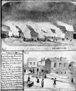
| Date: | 11 08 1906 |
|---|---|
| Description: | Two Civil War watercolor drawings by John Gaddis, Company E, 12th Wisconsin Volunteer Infantry, showing the regiment in bivouac, and later their headquarte... |
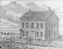
| Date: | 1836 |
|---|---|
| Description: | Drawing of the Solomon Juneau house on East Michigan. There are tethered bears on either side of the front door. Two people are leaning on the fence, watch... |
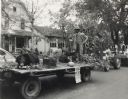
| Date: | 1950 |
|---|---|
| Description: | Bernard Arms holding a firearm poses on a parade float decorated in an autumn theme, including a stuffed bear, fox, and squirrel. The parade was a part of ... |

| Date: | 1758 |
|---|---|
| Description: | This map of the north-west hemisphere shows the cities, lakes, rivers, mountains, and political borders. In the upper left corner sits a decorative cartouc... |

| Date: | 1636 |
|---|---|
| Description: | Map of North America, divided into regions, and showing some rivers, lakes, settlements, cities, mountains, and Native American land. Of the Great Lakes on... |

| Date: | 1766 |
|---|---|
| Description: | This map of North America shows the boundaries of European claims at the end of the French and Indian war. The British colonies extend to the Mississippi. ... |
If you didn't find the material you searched for, our Library Reference Staff can help.
Call our reference desk at 608-264-6535 or email us at: