Filter: Categories of Wisconsin Historical Images
Filter: Subject of Bears
Filter: Subject of land
Filter: Subject of water
Filter: Categories of Wisconsin Historical Images
Filter: Subject of Bears
Filter: Subject of land
Filter: Subject of water

| Date: | 1930 |
|---|---|
| Description: | Pictorial map of Glacier National Park, Montana and Waterton Lakes National Park, Alberta. Illustrated by Joe Scheurle, it depicts white people, American ... |
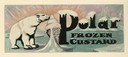
| Date: | 07 02 1935 |
|---|---|
| Description: | Label submitted to the State of Wisconsin for trademark registration. Features a polar bear licking a large ice cream cone. There are floating blocks of ic... |

| Date: | 1758 |
|---|---|
| Description: | This map of the north-west hemisphere shows the cities, lakes, rivers, mountains, and political borders. In the upper left corner sits a decorative cartouc... |

| Date: | 1636 |
|---|---|
| Description: | Map of North America, divided into regions, and showing some rivers, lakes, settlements, cities, mountains, and Native American land. Of the Great Lakes on... |
If you didn't find the material you searched for, our Library Reference Staff can help.
Call our reference desk at 608-264-6535 or email us at: