 Filter: Categories of Wisconsin Historical Images
Filter: Subject of Bears
Filter: Subject of indians of north america
Filter: Categories of Wisconsin Historical Images
Filter: Subject of Bears
Filter: Subject of indians of north america

| Date: | 1844 |
|---|---|
| Description: | Indian dance, with some wearing bear masks (Plate 18). "Next in importance to the buffalo hunts, and not less exciting and spirited in its character, is ... |

| Date: | 1844 |
|---|---|
| Description: | Indians on horseback trying to kill a bear (Plate 19). "The preliminaries of the hunt for the Grizzly Bear having been settled in the manner described in... |

| Date: | 1930 |
|---|---|
| Description: | Pictorial map of Glacier National Park, Montana and Waterton Lakes National Park, Alberta. Illustrated by Joe Scheurle, it depicts white people, American ... |
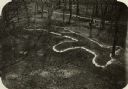
| Date: | |
|---|---|
| Description: | Elevated view of bear effigy mound outlined in chalk at Lake Koshkonong. |

| Date: | 11 14 1942 |
|---|---|
| Description: | This pictorial map illustrates Potawatomi Indian legends from the region of Lower Phantom Lake, labeled Howitt Lake on the map, Phantom Lake, and Mukwonag... |

| Date: | 1907 |
|---|---|
| Description: | Chippewa woman standing outdoors stirring one of three pots suspended over an open fire. |

| Date: | 1758 |
|---|---|
| Description: | This map of the north-west hemisphere shows the cities, lakes, rivers, mountains, and political borders. In the upper left corner sits a decorative cartouc... |

| Date: | 1636 |
|---|---|
| Description: | Map of North America, divided into regions, and showing some rivers, lakes, settlements, cities, mountains, and Native American land. Of the Great Lakes on... |

| Date: | 1766 |
|---|---|
| Description: | This map of North America shows the boundaries of European claims at the end of the French and Indian war. The British colonies extend to the Mississippi. ... |
If you didn't find the material you searched for, our Library Reference Staff can help.
Call our reference desk at 608-264-6535 or email us at: