 Filter: Categories of Wisconsin Historical Images
Filter: Subject of Bays
Filter: Year of 1900-1999
Filter: Year of 1950-1959
Filter: Categories of Wisconsin Historical Images
Filter: Subject of Bays
Filter: Year of 1900-1999
Filter: Year of 1950-1959
| Date: | 1950 |
|---|---|
| Description: | Downtown Ephraim from Peninsula State Park, directly across the bay. |

| Date: | 1950 |
|---|---|
| Description: | Aerial view of the confluence of the Fox River and Green Bay. |
| Date: | 1955 |
|---|---|
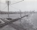
| Description: | Elevated view of the Milwaukee Road and Chicago & Northwestern Railway crossing on Monona Bay, the site of the old MX tower. |

| Date: | 1954 |
|---|---|
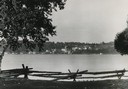
| Description: | View looking west from Eagle Bluff toward Nicolet Bay, the Strawberry Islands, and Chambers Island. Three people are sitting on the stone wall of the overl... |

| Date: | 1957 |
|---|---|
| Description: | Large Letter style postcard for Green Bay depicting various scenes in the letters that spell the name of the city. Caption reads: "Greetings from Green Bay... |

| Date: | 1952 |
|---|---|
| Description: | This 1952 map of the northern parts of Bayfield and Douglas counties, Wisconsin, shows points established by E.T. Sweet in 1877, road points confirmed by S... |

| Date: | 1950 |
|---|---|
| Description: | Map is ink and color on a photocopied base map. Map shows district limits, proposed future limits, and names of land owners. Base map, by A.A. Porath, show... |

| Date: | 1951 |
|---|---|
| Description: | This map has depths shown by bathymetric tints and soundings and relief shown by contours, the depths are shown in feet. There is an inset map of Green Bay... |

| Date: | 09 1950 |
|---|---|
| Description: | This map show streets, points of interest, Lake Winnebago and bays, Lake Butte Des Morts, and the Fox River. The back of the map includes a directory of t... |

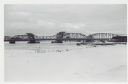
| Date: | 01 06 1958 |
|---|---|
| Description: | Ahnapee & Western Railway Bridge construction. View is from Highway Bridge. There are ships on the right side beyond the bridge. The forested shoreline cur... |

| Date: | 01 06 1958 |
|---|---|
| Description: | Ahnapee & Western Railway Bridge from north side of frozen Sturgeon Bay. The bridge is made of wood (and steel supports???). There is a dock in the foregro... |

| Date: | 01 06 1958 |
|---|---|
| Description: | View of the Ship Canal from the Coast Guard station. There are pieces of machinery on the right, and a line of trees on the left. There is snow on the grou... |
| Date: | 01 06 1958 |
|---|---|
| Description: | View from snowy shoreline of Mooring Basin at bay end of Ship Canal. The boat moored in the foreground is named "Allie." It is tethered to a post on the sh... |
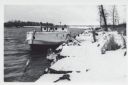
| Date: | 01 06 1958 |
|---|---|
| Description: | View from snowy shoreline of Highway Bridge, the east approach. The lake is frozen. Just beyond the shoreline a boat is moored at a landing, and an automob... |

| Date: | 01 01 1959 |
|---|---|
| Description: | This map shows many of the rivers, dams, bays, harbors, lakes, and canals. It includes an index of authorized federal project, both for navigation and floo... |
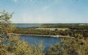
| Date: | 1957 |
|---|---|
| Description: | Elevated view of Little Sister Bay and the surrounding landscape. |

| Date: | 1952 |
|---|---|
| Description: | Kodachrome reproduction of the view over the rooftops of Ephraim towards Eagle Bay. Text on reverse reads: "Portraying the beauty and charm of picturesq... |

| Date: | 04 24 1957 |
|---|---|
| Description: | A city parks department worker helps with the spring clean-up by raking the lawn at Brittingham Park beside Monona Bay. |

| Date: | 08 10 1957 |
|---|---|
| Description: | Unidentified man taking a picture of the Lotus Bed on Lake Mendota. The bed of large, floating white blossoms are at the peak of their bloom. |

| Date: | 09 26 1957 |
|---|---|
| Description: | Elevated view of the West Tower of the State Office Building at 1 West Wilson Street while it is under construction. Steel vertical and horizontal members,... |
If you didn't find the material you searched for, our Library Reference Staff can help.
Call our reference desk at 608-264-6535 or email us at: