Filter: Categories of Wisconsin Historical Images
Filter: Subject of Bays
Filter: Year of 1800-1899
Filter: County of Ashland
Filter: Categories of Wisconsin Historical Images
Filter: Subject of Bays
Filter: Year of 1800-1899
Filter: County of Ashland

| Date: | 1898 |
|---|---|
| Description: | Old Mission Residence at La Pointe, Madeline Island. |
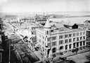
| Date: | 1891 |
|---|---|
| Description: | Elevated view looking west from the Knight Block. The Chequamegon Hotel and harbor are in the background. |

| Date: | 1885 |
|---|---|
| Description: | Ore dock of the Milwaukee, Lake Shore, and Western Railroad, with a pile of logs in the foreground and docked ships in the background. |

| Date: | 1885 |
|---|---|
| Description: | View of the ore dock of the Milwaukee, Lake Shore, and Western Railroad. Large logs, buildings and a railroad bridge are in the foreground. |

| Date: | 1850 |
|---|---|
| Description: | Map is pen and pencil on paper. The map shows roads, creeks, and the Chequamegon Bay. The map is undated and prepared sometime between the establishment of... |

| Date: | 1888 |
|---|---|
| Description: | This map shows wards and includes the Chequamegon Bay and Washburn. An inset map shows the Ashland region, its railroads, and a few of its iron mines. |
If you didn't find the material you searched for, our Library Reference Staff can help.
Call our reference desk at 608-264-6535 or email us at: