 Filter: Categories of Wisconsin Historical Images
Filter: Subject of Bays
Filter: Subject of land use
Filter: Categories of Wisconsin Historical Images
Filter: Subject of Bays
Filter: Subject of land use

| Date: | 1898 |
|---|---|
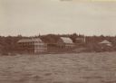
| Description: | Old Mission Residence at La Pointe, Madeline Island. |
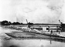
| Date: | 1907 |
|---|---|
| Description: | A steam-powered dredge anchored in Monona Bay is filling in Brittingham Park. |
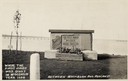
| Date: | 1931 |
|---|---|
| Description: | View of the Radisson-Groseilliers house historic site marker in the vicinity of Ashland. The marker was unveiled at the mouth of Fish Creek on October 25, ... |
| Date: | 1655 |
|---|---|
| Description: | Front view of the Radisson cabin, the first house built by a white man in Wisconsin. It was built between 1650 and 1660 on Chequamegon Bay, in the vicinity... |
| Date: | 1944 |
|---|---|
| Description: | View of the Radisson and Groseilliers marker at the site of the first house built by white men in Wisconsin. The marker is located in the vicinity of Ashla... |
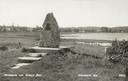
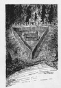
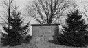
| Date: | 1940 |
|---|---|
| Description: | Memorial to the Moravians who arrived in Eagle Bay in 1853. |

| Date: | 1915 |
|---|---|
| Description: | View from hill across Eagle Bay with buildings and trees in the foreground. Caption reads: "Across Eagle Bay, Ephraim, Wis." |
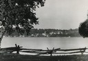
| Date: | 1950 |
|---|---|
| Description: | Downtown Ephraim from Peninsula State Park, directly across the bay. |

| Date: | 1905 |
|---|---|
| Description: | View across field and fence downhill towards the town of Fish Creek and the bay. Caption reads: "Greetings from Fish Creek, Wis." |

| Date: | 1905 |
|---|---|
| Description: | Indian cemetery. A large body of water is in the background. Caption reads: "Indian Burying Grounds, Bayfield, Wis." |
| Date: | 1905 |
|---|---|
| Description: | View across water towards Old Mission, as seen from the pier with Old Mission Congregational Church behind it. This Mission was established in 1830 by Fred... |

| Date: | 1916 |
|---|---|
| Description: | This Wisconsin Conservation Commission map from 1916 shows Peninsula State Park in the Town of Gibraltar, Door County, Wisconsin. Depicted are open and pla... |

| Date: | 1916 |
|---|---|
| Description: | This version of a 1916 Wisconsin Conservation Commission map shows Peninsula State Park in the Town of Gibraltar, Door County, Wisconsin. Depicted are open... |

| Date: | 1913 |
|---|---|
| Description: | Ink and watercolor on tracing cloth. Shows parts of Green Lake, Princeton, and Brooklyn townships, Indian mound groups, Green Lake, and other significant b... |

| Date: | 1941 |
|---|---|
| Description: | Elevated view of Sturgeon Bay in 1900. Sturgeon Bay Bridge spans the bay and several boats are on the water. A lighthouse sits on a small island in the bay... |

| Date: | 1915 |
|---|---|
| Description: | This map shows school houses, churches, farms, and railroads. Chequamecon Bay and Bad River Indian Reservation are labeld. The map reads: "All lands shown ... |
| Date: | 08 2013 |
|---|---|
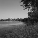
| Description: | View from shoreline of natural plants and trees towards the Madison skyline from across Monona Bay. A line of high-rise buildings frame the Wisconsin State... |
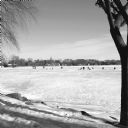
| Date: | 01 2014 |
|---|---|
| Description: | View from shoreline on a sunny day of snow-covered, frozen Monona Bay. People in the distance are standing or sitting near ice fishing holes and ice fishin... |
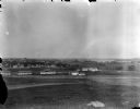
| Date: | |
|---|---|
| Description: | View from University Heights looking south across open fields towards barns and fences. (written on envelope: Camp Randall, Old Dane Country Fair Grounds).... |
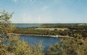
| Date: | 1957 |
|---|---|
| Description: | Elevated view of Little Sister Bay and the surrounding landscape. |
If you didn't find the material you searched for, our Library Reference Staff can help.
Call our reference desk at 608-264-6535 or email us at: