 Filter: Categories of Wisconsin Historical Images
Filter: Subject of Bays
Filter: Subject of land
Filter: Categories of Wisconsin Historical Images
Filter: Subject of Bays
Filter: Subject of land

| Date: | 1781 |
|---|---|
| Description: | Map of the British territory of West Florida, extending from the Mississippi River to the Apalachicola River. It shows the borders, cities, towns, forts, h... |

| Date: | 1761 |
|---|---|
| Description: | Map covering southern Louisiana from Lake Ponchetrain to the Golf of Mexico and from Woods Bay in the west to the islands just east of Bay St. Louis. It sh... |

| Date: | 1759 |
|---|---|
| Description: | Map of New Orleans at the start of the French & Indian War, including two inset maps entitled "The Course of the Mississipi River from Bayagoulas to the Se... |

| Date: | 1769 |
|---|---|
| Description: | Map of New Orleans at the start of the French & Indian War, including two inset maps of the Mississippi River Delta and Fort la Balise. It shows streets, r... |
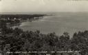
| Date: | |
|---|---|
| Description: | Elevated view of Green Bay from the Alpine Tower at Egg Harbor. A few dwellings are along the shoreline on the left. Caption reads: "View from the Alpine T... |

| Date: | 1933 |
|---|---|
| Description: | This map contains automobile routes across Wisconsin and portions of Illinois, Iowa, Minnesota and Michigan as well. The state borders are clearly defined... |
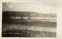
| Date: | |
|---|---|
| Description: | View of Beach Road and the beach at Ellison Bay. Buildings are across the bay, and a tree-lined ridge is in the far background. Caption reads: "Beach Road,... |
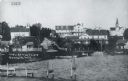
| Date: | 1915 |
|---|---|
| Description: | View of Ephraim from the bay, with a pier in the foreground. Churches are on the left and right, and the Hillside Hotel is in the center near the shore. Ca... |
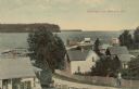
| Date: | |
|---|---|
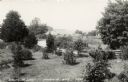
| Description: | Elevated view from hill of the bay and Ephraim. A man is walking up the hill on a road with buildings and fences on both sides. Caption reads: "Greetings f... |

| Date: | |
|---|---|
| Description: | Elevated view of Green Bay from Ephraim. There is an island in the bay. Caption reads: "Lake View from Scandinavian Peasant Craft Shop, Ephraim, Wis." |

| Date: | |
|---|---|
| Description: | Elevated view of the bay side neighborhood, with a view of the bluffs across the bay. Caption reads: "View of Bay at Ephraim from Anderson's House." |
| Date: | |
|---|---|
| Description: | Photographic postcard view of Ephraim and bay from a grassy lot with trees, shrubs and a fence. Caption reads: "Ephraim Bay, Ephraim, Wis." |

| Date: | 1909 |
|---|---|
| Description: | View across water towards the steep shoreline and lighthouse at Eagle Harbor. |

| Date: | |
|---|---|
| Description: | Drawing of a map showing the cruise routes from Eagle Inn Dock and the points of interest. There is a schedule and rates on the reverse. |
| Date: | 1907 |
|---|---|
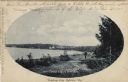
| Description: | Oval framed view of Ephraim from across the bay. A man is standing in the foreground. Caption reads: "Greetings from Ephraim, Wis." |

| Date: | |
|---|---|
| Description: | View from water towards Eagle Cliff (Bluff) in Peninsula State Park Caption reads: "Eagle Cliff, Ephraim, Wis." |
| Date: | 1935 |
|---|---|
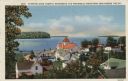
| Description: | Hand-colored elevated view from hill of Ephraim, Eagle Bay and Peninsula State Park. Dwellings and a church are in the foreground. Caption reads: "Ephraim,... |
| Date: | |
|---|---|
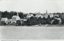
| Description: | Black and white photographic postcard view of Ephraim from Eagle Bay. Churches and dwellings are on the hill above the shoreline. Caption reads: "Greetings... |

| Date: | |
|---|---|
| Description: | Aerial view of Ephraim and Eagle Bay. A two-lane highway runs along the coastline. Caption reads: "Ephraim, Wisconsin." |
If you didn't find the material you searched for, our Library Reference Staff can help.
Call our reference desk at 608-264-6535 or email us at:
