 Filter: Categories of Wisconsin Historical Images
Filter: Subject of Bays
Filter: Subject of great lakes
Filter: Categories of Wisconsin Historical Images
Filter: Subject of Bays
Filter: Subject of great lakes

| Date: | 01 06 1958 |
|---|---|
| Description: | View of the Ship Canal from the Coast Guard station. There are pieces of machinery on the right, and a line of trees on the left. There is snow on the grou... |
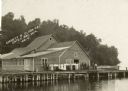
| Date: | |
|---|---|
| Description: | View across water towards a group of people, men, woman, and young girls and boys, posing on a pier in front of a building on the shoreline of Sister Bay. ... |

| Date: | 1905 |
|---|---|
| Description: | This map shows railroads, towns, lights, lights to be established, fog signals, light-vessels, lighted buoys, light-house depots, and light-house reservati... |

| Date: | 1905 |
|---|---|
| Description: | This map shows railroads, towns, lights, lights to be established, fog signals, light-vessels, lighted buoys, light-house depots, and light-house reservati... |
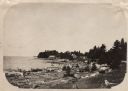
| Date: | 1910 |
|---|---|
| Description: | View along shoreline of Weborg Point before the area became Peninsula State Park. Green Bay is on the left. Two wood buildings are along the shoreline in t... |

| Date: | 1872 |
|---|---|
| Description: | This map includes depth shown by soundings and isolines and relief shown by contours. Tree species and locations are labeled, as well as a cranberry meadow... |

| Date: | 1710 |
|---|---|
| Description: | A seminal and fairly accurate map of the Great Lakes Region up to Baffin's Bay in Northern Canada. This is possibly the first printed map to locate Detroit... |

| Date: | 1696 |
|---|---|
| Description: | This sea chart and topographical map depicts the north east coast of Canada and North America, focusing on the Hudson Bay and Great Lakes regions. It shows... |

| Date: | 1780 |
|---|---|
| Description: | Map of North America from Lake Ontario through the Great Plains, and James Bay to Illinois. It shows rivers, lakes, and mountains in great detail, and labe... |
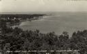
| Date: | |
|---|---|
| Description: | Elevated view of Green Bay from the Alpine Tower at Egg Harbor. A few dwellings are along the shoreline on the left. Caption reads: "View from the Alpine T... |

| Date: | |
|---|---|
| Description: | Drawing of a map showing the cruise routes from Eagle Inn Dock and the points of interest. There is a schedule and rates on the reverse. |

| Date: | |
|---|---|
| Description: | Aerial view of Ephraim and Eagle Bay. A two-lane highway runs along the coastline. Caption reads: "Ephraim, Wisconsin." |

| Date: | 1846 |
|---|---|
| Description: | Chart of Green Bay showing depths and locations of numerous islands at a scale of 1 inch to 2 miles. There is also a profile of the dividing ridge at Sturg... |

| Date: | 1978 |
|---|---|
| Description: | Text on reverse reads: "The Seamen's Memorial Statue, Barker's Island, Superior, WI. Facing the harbor holding a massive cable is the 10 foot tall Seamen's... |

| Date: | 09 1918 |
|---|---|
| Description: | An insurance map of Washburn, with an index and a key. Includes a small inset map of the State of Wisconsin that shows "Location of this town as above unde... |
If you didn't find the material you searched for, our Library Reference Staff can help.
Call our reference desk at 608-264-6535 or email us at: