 Filter: Categories of Wisconsin Historical Images
Filter: Subject of Bays
Filter: Subject of fruit
Filter: Categories of Wisconsin Historical Images
Filter: Subject of Bays
Filter: Subject of fruit

| Date: | 1676 |
|---|---|
| Description: | Map of Virginia and Maryland, based on John Smith's 1612 map and Augustine Herman's 1673 seminal map. It shows borders, counties, Native American land, tri... |
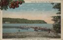
| Date: | |
|---|---|
| Description: | Color postcard view towards the shoreline, with a pier and three boats moored to it. On the far right is a portion of what may be a boathouse. There are bu... |
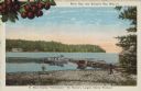
| Date: | 1915 |
|---|---|
| Description: | Caption reads: "Sister Bay, near Sturgeon Bay, Wis." and "In Door County 'Cherryland,' the Nation's Largest Cherry Producer." Sister Bay from a rocky beach... |
If you didn't find the material you searched for, our Library Reference Staff can help.
Call our reference desk at 608-264-6535 or email us at: