 Filter: Categories of Wisconsin Historical Images
Filter: Subject of Bays
Filter: Subject of cities and towns
Filter: Categories of Wisconsin Historical Images
Filter: Subject of Bays
Filter: Subject of cities and towns

| Date: | 01 01 1959 |
|---|---|
| Description: | This map shows many of the rivers, dams, bays, harbors, lakes, and canals. It includes an index of authorized federal project, both for navigation and floo... |
| Date: | |
|---|---|
| Description: | Stereograph of an elevated view of Howard Side of Green Bay. View looks over roofs of long, industrial buildings near railroad tracks that run over the wat... |

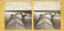
| Date: | 1899 |
|---|---|
| Description: | This map shows color coded and numbered regions of Indian land cessions. Lake Superior and Lake Michigan are labeled and other lakes and rivers are shown. ... |
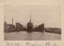
| Date: | 1902 |
|---|---|
| Description: | View across water towards a ship docked in a floating harbor at Sturgeon Bay. There is a shoreline in the background. |

| Date: | 1900 |
|---|---|
| Description: | This photocopy plat map of a paper city on the southeastern shore of Green Bay, probably in Brown County. The front includes a registration and the back in... |

| Date: | 1900 |
|---|---|
| Description: | Map showing a paper city located on the shore of Green Bay and south shore of the Fox River. The site is now part of Oshkosh. |

| Date: | 01 2014 |
|---|---|
| Description: | View from shoreline on a sunny day of snow-covered, frozen Monona Bay. People in the distance are standing or sitting near ice fishing holes and ice fishin... |

| Date: | 1917 |
|---|---|
| Description: | This road map shows routes through the state as well as some portions of Iowa, Minnesota, and Michigan. Cities, the Mississippi River, Lake Winnebago, Gree... |

| Date: | 1927 |
|---|---|
| Description: | This map details automobile routes throughout the state as well as parts of Iowa, Minnesota, Michigan and Illinois. Cities, the Mississippi River, Lake Mic... |

| Date: | 1910 |
|---|---|
| Description: | This map shows automobile routes across the state as well as Minnesota, Iowa, Illinois, and Michigan. Cities, Lake Michigan, Lake Superior, the Mississippi... |

| Date: | 1915 |
|---|---|
| Description: | This map includes automobile routes through the state as well as routes in parts of Iowa, Michigan and Minnesota. Cities, counties, Lake Michigan, Lake Sup... |

| Date: | 1920 |
|---|---|
| Description: | This map details automobile routes spanning across Wisconsin and parts of Illinois, Michigan, Minnesota, and Iowa. Cities, counties, Lake Michigan, Lake Su... |

| Date: | 1894 |
|---|---|
| Description: | This map shows automobile routes across the state and into parts of Illinois, Michigan, Minnesota, and Iowa. Cities, counties, Lake Michigan, Lake Superior... |

| Date: | 1913 |
|---|---|
| Description: | This map details automobile routes throughout the state and parts of Illinois, Minnesota, Michigan, and Iowa. Cities, counties, Lake Michigan, Lake Superio... |

| Date: | 1924 |
|---|---|
| Description: | This map shows automobile routes across the state and into parts of Minnesota, Iowa, Illinois, and Michigan. Cities, Lake Michigan, Lake Superior, Green Ba... |

| Date: | 1919 |
|---|---|
| Description: | This map contains the automobile routes in southern Wisconsin and northern Illinois. Cities, Lake Winnebago and Green Bay are labeled. The orange print on ... |

| Date: | 1915 |
|---|---|
| Description: | This map displays various automobile routes through the state of Wisconsin and parts of Illinois, Iowa, Minnesota, and Michigan. Cities, counties, Lake Mic... |

| Date: | 1913 |
|---|---|
| Description: | This map displays automobile routes across Wisconsin as well as Minnesota, Iowa, Michigan and Illinois. Cities, counties, Lake Michigan, Lake Superior, Gre... |

| Date: | 1710 |
|---|---|
| Description: | A seminal and fairly accurate map of the Great Lakes Region up to Baffin's Bay in Northern Canada. This is possibly the first printed map to locate Detroit... |

| Date: | 1746 |
|---|---|
| Description: | Map of North America from the southern portion of James Bay to Florida. It shows the colonies, cities, Native American land, and topological and geographic... |
If you didn't find the material you searched for, our Library Reference Staff can help.
Call our reference desk at 608-264-6535 or email us at: