 Filter: Categories of Wisconsin Historical Images
Filter: Subject of Bays
Filter: Subject of bays
Filter: Subject of recreation areas
Filter: Categories of Wisconsin Historical Images
Filter: Subject of Bays
Filter: Subject of bays
Filter: Subject of recreation areas
| Date: | 1906 |
|---|---|
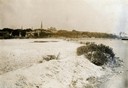
| Description: | View of Madison from Lake Monona with the Wisconsin State Capitol building in the background. This view of Brittingham Park shows a part of the park shortl... |
| Date: | 1907 |
|---|---|
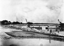
| Description: | A steam-powered dredge anchored in Monona Bay is filling in Brittingham Park. |

| Date: | 1944 |
|---|---|
| Description: | Shows roads, railroads, schools, dairy plants, seaplane bases, wayside parks, and commercial/municipal fields. "Marathon Forms Map Service, Wisconsin repre... |

| Date: | 1908 |
|---|---|
| Description: | The map reads: "Feb. 3, 1908." Oriented with north to the lower left. Lake Monona, Monona Bay, and Brittingham Park are labelled. |

| Date: | 1974 |
|---|---|
| Description: | This map shows roads, highways, railroads, major arterials, towns, parks, recreational areas, and parts of Fox River and bay of Green Bay. The map includes... |

| Date: | 1900 |
|---|---|
| Description: | This map is shows land in white and water in blue and is indexed for parks, points of interest, schools, churches, and recreational areas. The map shows lo... |

| Date: | 1890 |
|---|---|
| Description: | This map shows lot and block numbers, established dock lines, docks, slips, railroads, streets, selected industrial buildings, sites for manufactories, and... |

| Date: | 1894 |
|---|---|
| Description: | This map shows lot and block numbers, railroads, street car tracks, sewers, water mains, gas mains, paved streets, land owned by the Land & River Improveme... |

| Date: | 1963 |
|---|---|
| Description: | This blue line print shows as of March 1960 federal, state, county, and town roads, as well as railroads, schools, churches, town hall, parks, and Brown Co... |

| Date: | 1924 |
|---|---|
| Description: | This map shows streets, selected buildings, railroads, railway yards, schools, parks, schools, cemeteries, bays, the Milwaukee River, and Lake Michigan. De... |

| Date: | 1960 |
|---|---|
| Description: | This map shows public boat ramps, parks, highways, beaches, bluffs, Green Bay, Garrett Bay, Europe Bay and Lake, Rowley's Bay and Ellison Bay. The map incl... |

| Date: | 1936 |
|---|---|
| Description: | This map shows campsites, trails, auto roads, surrounding townships, and points of interest, by including pictorial illustrations. Includes an inserted map... |
| Date: | 01 2014 |
|---|---|
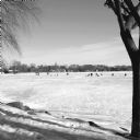
| Description: | View from shoreline on a sunny day of snow-covered, frozen Monona Bay. People in the distance are standing or sitting near ice fishing holes and ice fishin... |

| Date: | 1933 |
|---|---|
| Description: | This road map shows automobile routes across Wisconsin as well as portions of Illinois, Minnesota, Iowa and Michigan. Lakes Michigan, Superior and Winnebag... |

| Date: | 1933 |
|---|---|
| Description: | This map contains automobile routes across Wisconsin and portions of Illinois, Iowa, Minnesota and Michigan as well. The state borders are clearly defined... |

| Date: | 08 20 2014 |
|---|---|
| Description: | View of Monona Bay. Grass and trees are growing along the shoreline. Downtown Madison, including the Wisconsin State Capitol, is on the opposite shoreline. |
| Date: | 1914 |
|---|---|
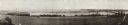
| Description: | Panoramic view of Brittingham Bay taken from the north west shore of Brittingham Park. The boathouse is on the left. On the right the railroad tracks cross... |

| Date: | 1960 |
|---|---|
| Description: | Air view focused on the Greenbush neighborhood of Madison prior to its demolition for the Triangle Redevelopment Project. Monona Bay and Brittingham Park a... |

| Date: | 04 24 1957 |
|---|---|
| Description: | A city parks department worker helps with the spring clean-up by raking the lawn at Brittingham Park beside Monona Bay. |

| Date: | 08 10 1957 |
|---|---|
| Description: | Unidentified man taking a picture of the Lotus Bed on Lake Mendota. The bed of large, floating white blossoms are at the peak of their bloom. |
If you didn't find the material you searched for, our Library Reference Staff can help.
Call our reference desk at 608-264-6535 or email us at: