 Filter: Categories of Wisconsin Historical Images
Filter: Subject of Bays
Filter: Subject of bays
Filter: Community of Sturgeon Bay
Filter: Subject of transportation
Filter: Categories of Wisconsin Historical Images
Filter: Subject of Bays
Filter: Subject of bays
Filter: Community of Sturgeon Bay
Filter: Subject of transportation

| Date: | 1893 |
|---|---|
| Description: | Bird's-eye map of Sturgeon Bay, looking Northeast. Area bordered by Church Street in top left corner, leather & Smith Bridge in bottom left corner, Lawrenc... |

| Date: | 1880 |
|---|---|
| Description: | Bird's-eye map of Sturgeon Bay. County Seat of Door County. |

| Date: | 1872 |
|---|---|
| Description: | This 1872 map shows the proposed route of a canal between Sturgeon Bay, on the Green Bay side of the Door Peninsula, and Lake Michigan. Depths in both Stur... |

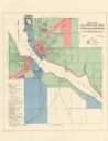
| Date: | 1943 |
|---|---|
| Description: | This map of Sturgeon Bay shows section and quarter corners, ward divisions, government building locations, roads, and railroads. The map includes a legend ... |

| Date: | 1941 |
|---|---|
| Description: | Elevated view of Sturgeon Bay in 1900. Sturgeon Bay Bridge spans the bay and several boats are on the water. A lighthouse sits on a small island in the bay... |

| Date: | 01 06 1958 |
|---|---|
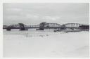
| Description: | Ahnapee & Western Railway Bridge construction. View is from Highway Bridge. There are ships on the right side beyond the bridge. The forested shoreline cur... |

| Date: | 01 06 1958 |
|---|---|
| Description: | Ahnapee & Western Railway Bridge from north side of frozen Sturgeon Bay. The bridge is made of wood (and steel supports???). There is a dock in the foregro... |

| Date: | 01 06 1958 |
|---|---|
| Description: | View of the Ship Canal from the Coast Guard station. There are pieces of machinery on the right, and a line of trees on the left. There is snow on the grou... |
| Date: | 01 06 1958 |
|---|---|
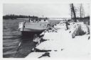
| Description: | View from snowy shoreline of Mooring Basin at bay end of Ship Canal. The boat moored in the foreground is named "Allie." It is tethered to a post on the sh... |
| Date: | 01 06 1958 |
|---|---|
| Description: | View from snowy shoreline of Highway Bridge, the east approach. The lake is frozen. Just beyond the shoreline a boat is moored at a landing, and an automob... |

| Date: | |
|---|---|
| Description: | Aerial view of harbors and bridge. Farm fields are on either side of the bridge. The city of Sturgeon Bay is in the distance. There are docks along the sho... |
| Date: | 1961 |
|---|---|
| Description: | This map shows zoning districts, wards, and house number system and is indexed for points of interest. The upper right corner includes a color coded zoning... |

| Date: | 04 1926 |
|---|---|
| Description: | This blueprint mostly shows various numbers within the canal and bay. Lake Michigan and Harobor of Refuge are shown along the far right side. Near the harb... |
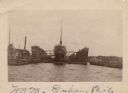
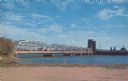
| Date: | 1902 |
|---|---|
| Description: | View across water towards a ship docked in a floating harbor at Sturgeon Bay. There is a shoreline in the background. |
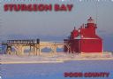
| Date: | 1963 |
|---|---|
| Description: | Text on front reads: "Sturgeon Bay, Door County." On reverse: "Sturgeon Bay, Wisconsin, Door County. North Pierhead Light. Winter shows its pretty face on ... |

| Date: | 07 06 1931 |
|---|---|
| Description: | Text on front reads: "Where Green Bay and Sturgeon Bay Meet, Sturgeon Bay, Wis." Aerial view of Sturgeon Bay showing the only bridge in existence at the ti... |
| Date: | 1955 |
|---|---|
| Description: | Text on reverse reads: "Sturgeon Bay Drawbridge Spanning, Sturgeon Bay Canal, Sturgeon Bay, Wis." Traffic is backed up as a ship passes through the span of... |
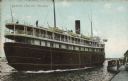
| Date: | 06 17 1908 |
|---|---|
| Description: | Text on front reads: "Goodrich Line Str. 'Carolina'." "Carolina of Duluth" is painted on the prow of the steamer. Passengers are lined up along the railing... |
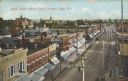
| Date: | 07 21 1908 |
|---|---|
| Description: | Text on front reads: "Cedar Street looking South, Sturgeon Bay, Wis." Elevated view of storefronts on a street, the west facing stores all have awnings. A ... |
If you didn't find the material you searched for, our Library Reference Staff can help.
Call our reference desk at 608-264-6535 or email us at: