 Filter: Categories of Wisconsin Historical Images
Filter: Subject of Bays
Filter: County of Ashland
Filter: Year of 1900-1999
Filter: Categories of Wisconsin Historical Images
Filter: Subject of Bays
Filter: County of Ashland
Filter: Year of 1900-1999

| Date: | 1929 |
|---|---|
| Description: | View of an ore dock on Chequamegon Bay. Buildings on the shore of the bay can be seen, however, not the water. |

| Date: | 1920 |
|---|---|
| Description: | Caption reads: "Mammoth Ore Docks, Ashland, Wis." A building and roads are in the foreground. Several ore ships can be seen. |
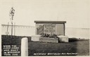
| Date: | 1931 |
|---|---|
| Description: | View of the Radisson-Groseilliers house historic site marker in the vicinity of Ashland. The marker was unveiled at the mouth of Fish Creek on October 25, ... |
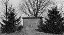
| Date: | 1944 |
|---|---|
| Description: | View of the Radisson and Groseilliers marker at the site of the first house built by white men in Wisconsin. The marker is located in the vicinity of Ashla... |

| Date: | 1905 |
|---|---|
| Description: | Indian cemetery. A large body of water is in the background. Caption reads: "Indian Burying Grounds, Bayfield, Wis." |
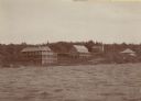
| Date: | 1905 |
|---|---|
| Description: | View across water towards Old Mission, as seen from the pier with Old Mission Congregational Church behind it. This Mission was established in 1830 by Fred... |

| Date: | 1900 |
|---|---|
| Description: | This chart of the northern Apostle Islands and Lake Superior shoreline shows relief by contours and spot heights and depths by contours, gradient tints and... |

| Date: | 1916 |
|---|---|
| Description: | This map shows Chequamegon Bay, an inlet of Lake Superior. Depths are shown by isolines and soundings and relief shown by contours. The map is colored in y... |

| Date: | 1900 |
|---|---|
| Description: | This map is shows land in white and water in blue and is indexed for parks, points of interest, schools, churches, and recreational areas. The map shows lo... |

| Date: | 1924 |
|---|---|
| Description: | This map is pen, pencil, and watercolor on paper and shows land ownership by name, local streets, railroads, and part of Chequamegon Bay. The map includes ... |

| Date: | 1900 |
|---|---|
| Description: | This map is pencil and ink on tracing cloth and shows local streets, railroads, harbor line, and part of Chequamegon Bay. |

| Date: | 06 1923 |
|---|---|
| Description: | Sanborn map of Ashland, which includes Chequamegon Bay. |

| Date: | 1915 |
|---|---|
| Description: | This map shows school houses, churches, farms, and railroads. Chequamecon Bay and Bad River Indian Reservation are labeld. The map reads: "All lands shown ... |

| Date: | 1909 |
|---|---|
| Description: | This map shows vacant Wisconsin Central Ry. lands, settlers houses, lands sold by Wisconsin Central Ry., schools, churches, saw mills, and roads; also show... |

| Date: | 1985 |
|---|---|
| Description: | This map shows mining, White River, Silver Creek, Bad River, Agogic Lake, Chequamegon Bay, smaller lakes, the Bad River Indian Reservation, and communities... |
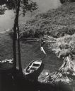
| Date: | 1956 |
|---|---|
| Description: | Elevated view of a rowboat moored in a small cove on Madeline Island in the Apostle Islands. |
If you didn't find the material you searched for, our Library Reference Staff can help.
Call our reference desk at 608-264-6535 or email us at:
