 Filter: Categories of Wisconsin Historical Images
Filter: Subject of Bays
Filter: Creator Name of Unknown
Filter: Categories of Wisconsin Historical Images
Filter: Subject of Bays
Filter: Creator Name of Unknown

| Date: | 1683 |
|---|---|
| Description: | Map of the north east coast of North America showing islands, regions, Native American land, bays, and a few European settlements. The Great Lakes appear i... |
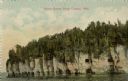
| Date: | |
|---|---|
| Description: | View across water towards the bluffs at the northern end of Door County. |

| Date: | 1775 |
|---|---|
| Description: | Map of Boston and surrounding regions, from Massachusetts Bay to the Connecticut River, and including part of southern New Hampshire. It shows the colonies... |

| Date: | 1780 |
|---|---|
| Description: | Map of Maryland and a portion of the surrounding provinces. It shows the boundary lines and borders, counties, cities, towns, roads, mountains, bays, and r... |

| Date: | 1765 |
|---|---|
| Description: | Map showing the new British territories of East and West Florida following the Treaty of Paris at the end of the French and Indian War. It shows boundaries... |

| Date: | 1761 |
|---|---|
| Description: | Map covering southern Louisiana from Lake Ponchetrain to the Golf of Mexico and from Woods Bay in the west to the islands just east of Bay St. Louis. It sh... |
| Date: | |
|---|---|
| Description: | Elevated view of Green Bay from the Alpine Tower at Egg Harbor. A few dwellings are along the shoreline on the left. Caption reads: "View from the Alpine T... |
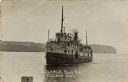
| Date: | |
|---|---|
| Description: | View of the Steamer "Bon Ami" on Ellison Bay. A few people are on the deck. The tree-lined far shoreline is in the background. Caption reads: "Steamer Bon ... |
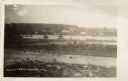
| Date: | |
|---|---|
| Description: | View of Beach Road and the beach at Ellison Bay. Buildings are across the bay, and a tree-lined ridge is in the far background. Caption reads: "Beach Road,... |
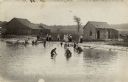
| Date: | 1919 |
|---|---|
| Description: | View towards shoreline with a group of people gathered at a bathing beach. Some people are in the water; other people are standing on the shore fully dress... |

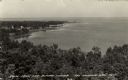
| Date: | |
|---|---|
| Description: | Elevated view of Green Bay from Ephraim. There is an island in the bay. Caption reads: "Lake View from Scandinavian Peasant Craft Shop, Ephraim, Wis." |

| Date: | |
|---|---|
| Description: | Elevated view of the bay side neighborhood, with a view of the bluffs across the bay. Caption reads: "View of Bay at Ephraim from Anderson's House." |

| Date: | 1909 |
|---|---|
| Description: | View across water towards the steep shoreline and lighthouse at Eagle Harbor. |

| Date: | |
|---|---|
| Description: | Drawing of a map showing the cruise routes from Eagle Inn Dock and the points of interest. There is a schedule and rates on the reverse. |

| Date: | 1944 |
|---|---|
| Description: | Elevated view of Fish Creek and Green Bay. Dwellings are in the foreground. The Peninsula State Park is across the bay. Caption reads: "Fish Creek, Wis. Fr... |

| Date: | |
|---|---|
| Description: | View from shoreline looking out towards the public beach with several bathers. Diving platforms are out in the bay. Caption reads: "Fish Creek, Wis. The Ba... |
| Date: | |
|---|---|
| Description: | Aerial view of Green Bay from the bay. Commercial and industrial buildings are in the foreground. Waterfront businesses include F. Hurlbut Cement and W.W. ... |
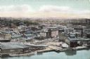
| Date: | 1918 |
|---|---|
| Description: | The pavilion and bath house at Bay View Beach. Bathers are walking in the shallow water in the foreground. Caption reads: "Pavilion and Bath House, Bay Vie... |

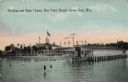
| Date: | 1901 |
|---|---|
| Description: | View across water towards the Steamer "Harriet A. Hart," with many passengers on board, and smoke coming out of the smokestack. Caption reads: "Steamer Har... |
If you didn't find the material you searched for, our Library Reference Staff can help.
Call our reference desk at 608-264-6535 or email us at:
