Filter: Categories of Wisconsin Historical Images
Filter: Subject of Battlefields
Filter: Subject of water
Filter: Categories of Wisconsin Historical Images
Filter: Subject of Battlefields
Filter: Subject of water
| Date: | 1856 |
|---|---|
| Description: | Painting by S.M. Brookes of the Wisconsin Heights Battlefield. |

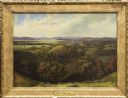
| Date: | 1856 |
|---|---|
| Description: | This landscape painting by Samuel Marsden Brookes and Thomas H. Stevenson depicts a broad view of the confluence of Bad Axe and Mississippi Rivers; site of... |
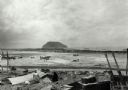
| Date: | 02 1945 |
|---|---|
| Description: | Airfield #1, Iwo Jima, with Mt Surabachi in the distance. This image is one of many taken by Milwaukee photographer Dickey Chapelle during the assault on ... |
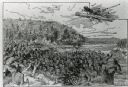
| Date: | |
|---|---|
| Description: | An illustration titled "The Battle of the Brule" based on an 1840's battle between the Ojibwe and Dakota Sioux over territory in the Ashland, Wisconsin are... |
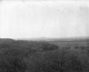
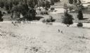
| Date: | 1896 |
|---|---|
| Description: | Elevated view. Caption on negative sleeve reads: "Black Hawk Battlefield. Wis. Heights. 'Looking it of west across river' [sic] c. 1896. Mrs. Charle... |

| Date: | |
|---|---|
| Description: | Plan of the battle of the horse shoe bend on the East Pecatonica. |

| Date: | 09 1918 |
|---|---|
| Description: | Elevated view of the U.S. Government War Exposition grounds at Grant Park. |

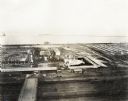
| Date: | 09 1918 |
|---|---|
| Description: | Elevated view of the U.S. Government War Exposition at Grant Park taken from a window the International Harvester building on Michigan Avenue. A large crow... |
| Date: | 09 1918 |
|---|---|
| Description: | Elevated view of the U.S. Government War Exposition at Grant Park taken from a window the International Harvester building on Michigan Avenue. A large crow... |
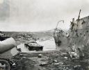
| Date: | 1945 |
|---|---|
| Description: | Parts of destroyed boats and military equipment on the shoreline of Iwo Jima on D-Day. |
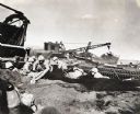
| Date: | 1945 |
|---|---|
| Description: | Marines dig foxholes into the sand on the beaches of Iwo Jima. The men are surrounded by military equipment, including a crane. An International Diesel cra... |
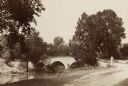
| Date: | 1890 |
|---|---|
| Description: | Site of the Battle of Antietam, the Burnside Bridge. |

| Date: | 1880 |
|---|---|
| Description: | A scene from a panoramic painting of Grant's assault on Vicksburg. |
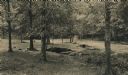
| Date: | 1900 |
|---|---|
| Description: | Spangler's Spring on the Gettysburg battlefield. |

| Date: | 1864 |
|---|---|
| Description: | View across the Tennessee River toward the city and Cameron Hill, showing the military bridge and some Union Army installations put up following the occupa... |

| Date: | 1866 |
|---|---|
| Description: | View of earthworks at the battlefield at Resacca. Dirt roads cross the field in the distance, leading to a farm and what appears to be a river. Plate 22... |

| Date: | 1864 |
|---|---|
| Description: | (U.S. 39th Cong. 1stt Sess. Report of Chief engineer) The legend in the upper left corner contains a brief resume of each day's action while the map sho... |

| Date: | 1861 |
|---|---|
| Description: | This map was reproduced photographically and issued in Augusta, Ga., in the early days of the Civil War. It includes panels showing Virginia, Maryland, the... |
If you didn't find the material you searched for, our Library Reference Staff can help.
Call our reference desk at 608-264-6535 or email us at: