Filter: Categories of Wisconsin Historical Images
Filter: Subject of Battlefields
Filter: Subject of roads
Filter: Categories of Wisconsin Historical Images
Filter: Subject of Battlefields
Filter: Subject of roads
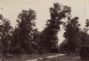
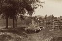
| Date: | 1890 |
|---|---|
| Description: | Hagerstown Pike. A brick wall and trees are along the road on the right. |

| Date: | 1885 |
|---|---|
| Description: | Chromolithograph advertising poster produced for the McCormick Harvesting Machine Company showing a McCormick binder stored in a shed in the middle of the ... |
| Date: | 1889 |
|---|---|
| Description: | Stereograph from the Chicago Panorama of the Battle of Gettysburg Representing Pickett's Charge at 4 P.M., July 3rd, 1863: Pike Leading from Cemetery Hill,... |
| Date: | 1889 |
|---|---|
| Description: | Stereograph from the Chicago Panorama of the Battle of Gettysburg Representing Pickett's Charge at 4 P.M., July 3rd, 1863: Woodruff's Battery on the Right ... |

| Date: | 09 1918 |
|---|---|
| Description: | Elevated view of the U.S. Government War Exposition at Grant Park taken from a window the International Harvester building on Michigan Avenue. A large crow... |
| Date: | 1890 |
|---|---|
| Description: | Site of the Battle of Antietam. The bloody lane. |
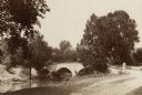
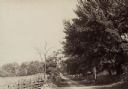
| Date: | 1890 |
|---|---|
| Description: | Site of the Battle of Antietam, the Burnside Bridge. |
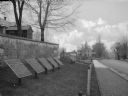
| Date: | |
|---|---|
| Description: | A view of eight commemorative tablets at the North Cemetery of Antietam Battlefield, the site of the bloodiest one-day battle in United States history in 1... |
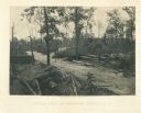
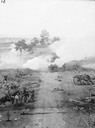
| Date: | 1866 |
|---|---|
| Description: | A dirt road passes through the battlefield, with fortifications on the sides. It is a lightly forested area. A horse and buggy are among some trees in the ... |

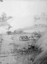
| Date: | 1866 |
|---|---|
| Description: | View of earthworks at the battlefield at Resacca. Dirt roads cross the field in the distance, leading to a farm and what appears to be a river. Plate 22... |

| Date: | 1876 |
|---|---|
| Description: | Detailed topographic map of the Gettysburg battlefield created thirteen years after the battle. This map shows day one of the battle. The map shows drainag... |

| Date: | 1862 |
|---|---|
| Description: | This map of the Battle of Shiloh shows relief by hachures, vegetation, drainage, houses, fields, fences, mills, and roads and is color coded to show the mo... |

| Date: | 1863 |
|---|---|
| Description: | This map is a hand-colored, pen and ink, drawing by Ole R. Dahl of Co. B, 15 Wisconsin Infantry shows the battlefield at Stones River, depicting roads, str... |

| Date: | 1863 |
|---|---|
| Description: | These detailed topographical maps of the Battle of Gettysburg show drainage, vegetation, roads, railroads, fences, houses with names of residents, and a de... |

| Date: | 1863 |
|---|---|
| Description: | These detailed topographical maps of the Battle of Gettysburg show drainage, vegetation, roads, railroads, fences, houses with names of residents, and a de... |

| Date: | 1863 |
|---|---|
| Description: | This colored map of the Battle of Chattanooga depicts the positions of the Union and Confederate troops before the battle and on each day of the battle. Al... |

| Date: | 1863 |
|---|---|
| Description: | This map shows drainage, vegetation, roads, railroads, fences, dwellings with names of inhabitants, and land owned by the United States. Union and Confeder... |

| Date: | 1863 |
|---|---|
| Description: | This map of the Battle of Chattanooga depicts roads, railroads, drainage, vegetation, relief, and the names of residents in the outlying areas. Fourteen Wi... |

| Date: | 1864 |
|---|---|
| Description: | This map of the Atlanta area shows entrenchments, relief by hachures, vegetation, drainage, roads, railroads, towns, and the names of a few residents in th... |
If you didn't find the material you searched for, our Library Reference Staff can help.
Call our reference desk at 608-264-6535 or email us at: