 Filter: Categories of Wisconsin Historical Images
Filter: Subject of Battlefields
Filter: Subject of dwellings
Filter: Subject of transportation
Filter: Categories of Wisconsin Historical Images
Filter: Subject of Battlefields
Filter: Subject of dwellings
Filter: Subject of transportation

| Date: | 09 1918 |
|---|---|
| Description: | Elevated view of the U.S. Government War Exposition at Grant Park taken from a window the International Harvester building on Michigan Avenue. A large crow... |
| Date: | 1890 |
|---|---|
| Description: | Site of the Battle of Antietam. The bloody lane. |
| Date: | 1862 |
|---|---|
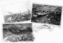
| Description: | A composite of three views showing the siege of New Ulm on August 19 during the Indian Massacre of 1862. The lower left view depicts wagons and horses on a... |

| Date: | 1942 |
|---|---|
| Description: | Advertising proof illustrating International Harvester's contribution to the war effort through the forming of maintenance battalions to service Internatio... |

| Date: | 1862 |
|---|---|
| Description: | This map of the Battle of Shiloh shows relief by hachures, vegetation, drainage, houses, fields, fences, mills, and roads and is color coded to show the mo... |

| Date: | 1863 |
|---|---|
| Description: | These detailed topographical maps of the Battle of Gettysburg show drainage, vegetation, roads, railroads, fences, houses with names of residents, and a de... |

| Date: | 1863 |
|---|---|
| Description: | These detailed topographical maps of the Battle of Gettysburg show drainage, vegetation, roads, railroads, fences, houses with names of residents, and a de... |

| Date: | 1863 |
|---|---|
| Description: | These detailed topographical maps of the Battle of Gettysburg show drainage, vegetation, roads, railroads, fences, houses with names of residents, and a de... |

| Date: | 1863 |
|---|---|
| Description: | This map shows drainage, vegetation, roads, railroads, fences, dwellings with names of inhabitants, and land owned by the United States. Union and Confeder... |

| Date: | 1864 |
|---|---|
| Description: | This map depicts the positions of Union forces, in blue, and Confederate forces, in red, at the end of 1863 after the cessation of the Knoxville Campaign. ... |

| Date: | 1864 |
|---|---|
| Description: | This map of the area of the First Battle of Bull Run shows military positions and troop movements as well as the names of landowners, vegetation and land u... |

| Date: | 1865 |
|---|---|
| Description: | This detailed map of the area between Richmond and Petersburg shows fortifications, roads, railroads, towns, street patterns of Petersburg and Richmond, dr... |

| Date: | 1866 |
|---|---|
| Description: | This detailed map shows the positions of the armies of the Ohio and Tennessee, Confederate lines, headquarters, "regimental camps at the date of the battle... |

| Date: | |
|---|---|
| Description: | Pen and ink tracing showing the positions of Union and Confederate soldiers, troop camps, location of graves, roads, drainage, vegetation, houses, and fenc... |

| Date: | 1865 |
|---|---|
| Description: | The map of the battlefield shows entrenchments, villages, roads, the "South Side Rail Road" drainage, vegetation, relief by hachures, houses, and names of ... |

| Date: | |
|---|---|
| Description: | This detailed map shows fortifications, headquarters, location and dates of battles, street outline of Atlanta, roads, railroads, vegetation, drainage, rel... |
If you didn't find the material you searched for, our Library Reference Staff can help.
Call our reference desk at 608-264-6535 or email us at: