 Filter: Categories of Wisconsin Historical Images
Filter: Subject of Battlefields
Filter: Subject of dwellings
Filter: Subject of land use
Filter: Categories of Wisconsin Historical Images
Filter: Subject of Battlefields
Filter: Subject of dwellings
Filter: Subject of land use
| Date: | 1889 |
|---|---|
| Description: | Stereograph from the Panorama of the Battle of Missionary Ridge, Captain R. Cobb and Retreat of 9th Kentucky Battery, painted in 1885. It was painted by Eu... |

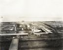
| Date: | 09 1918 |
|---|---|
| Description: | Elevated view of the U.S. Government War Exposition at Grant Park taken from a window the International Harvester building on Michigan Avenue. A large crow... |
| Date: | 09 1918 |
|---|---|
| Description: | Elevated view of the U.S. Government War Exposition at Grant Park taken from a window the International Harvester building on Michigan Avenue. A large crow... |
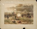
| Date: | 08 1862 |
|---|---|
| Description: | Color lithograph of Union lines in the midst of battle. |
| Date: | |
|---|---|
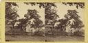
| Description: | A view of the Cedar Mountain Battlefield. Caption reads: "Cedar Mountain Battle Field, Culpeper, VA." |
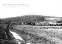
| Date: | 1890 |
|---|---|
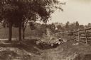
| Description: | Site of the Battle of Antietam. The bloody lane. |
| Date: | |
|---|---|
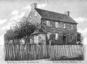
| Description: | A fence surrounds an old stone house and trees at Bull Run Battlefield. Caption reads: "Stone House, Bull Run Battlefield, Va." |
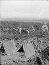
| Date: | 1866 |
|---|---|
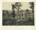
| Description: | Broken trees in front of a field with a fence. There is a small building on a hill in the background. Plate 20 |

| Date: | 1863 |
|---|---|
| Description: | These detailed topographical maps of the Battle of Gettysburg show drainage, vegetation, roads, railroads, fences, houses with names of residents, and a de... |

| Date: | 1863 |
|---|---|
| Description: | These detailed topographical maps of the Battle of Gettysburg show drainage, vegetation, roads, railroads, fences, houses with names of residents, and a de... |

| Date: | |
|---|---|
| Description: | Pen and ink tracing showing the positions of Union and Confederate soldiers, troop camps, location of graves, roads, drainage, vegetation, houses, and fenc... |
| Date: | 07 1863 |
|---|---|
| Description: | Stereograph of the farmhouse of Abram Bryant, a free black man who lived near Gettysburg, Pennsylvania. An African American man is standing near the porch ... |
If you didn't find the material you searched for, our Library Reference Staff can help.
Call our reference desk at 608-264-6535 or email us at: