Filter: Categories of Wisconsin Historical Images
Filter: Subject of Battlefields
Filter: Reproduction Rights of For Sale
Filter: Categories of Wisconsin Historical Images
Filter: Subject of Battlefields
Filter: Reproduction Rights of For Sale
| Date: | 1866 |
|---|---|
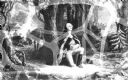
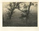
| Description: | A clearing in some trees with an animal skull where Union General McPherson died. Plate 35 |
| Date: | 1866 |
|---|---|
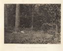
| Description: | The aftermath of the Battle of Peach Tree Creek. Union graves are in the foreground, with a field in the middle, and a forest in the background. Plate 3... |
| Date: | 1866 |
|---|---|
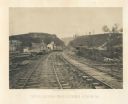
| Description: | View from railroad tracks through the Allatoona Pass. One of the buildings on the left says "Grocery," and piles of lumber are stacked along the sides of t... |
| Date: | 1866 |
|---|---|
| Description: | Two men stand on either side of an opening in the earthworks at Allatoona Pass. Mountains are in the distance. Plate 28 |
| Date: | 1866 |
|---|---|
| Description: | Aftermath of the battle at New Hope, a hillside covered with broken and barren trees. Plate 27 |
| Date: | 1866 |
|---|---|
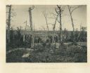
| Description: | An earth mound with some burlap sacks covering it. Many barren trees surround the scene. Plate 26 |
| Date: | 1866 |
|---|---|
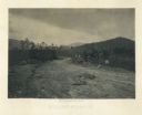
| Description: | A dirt road passes through the battlefield, with fortifications on the sides. It is a lightly forested area. A horse and buggy are among some trees in the ... |

| Date: | 1866 |
|---|---|
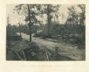
| Description: | View of earthworks at the battlefield at Resacca. Dirt roads cross the field in the distance, leading to a farm and what appears to be a river. Plate 22... |
| Date: | 1866 |
|---|---|
| Description: | Barren and battered trees on the Resacca battlefield. There is a house in a valley in the distance. Plate 21 |
| Date: | 1866 |
|---|---|
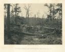
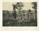
| Description: | Broken trees in front of a field with a fence. There is a small building on a hill in the background. Plate 20 |
| Date: | 1866 |
|---|---|
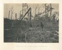
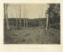
| Description: | Trees stripped of bark. There is a fence on the right. In the far background is a building, perhaps a house, on a hill. Plate 19 |
| Date: | 1866 |
|---|---|
| Description: | View across road of one man sitting on a log, and another man lying on the ground near the opposite side of the road. Debris surrounds them, and in the bac... |
| Date: | 1866 |
|---|---|
| Description: | View of Ringgold in the far distance. A tree and pile of rubble, perhaps the remains of a fireplace, in the foreground. Plate 17 |
| Date: | 1866 |
|---|---|
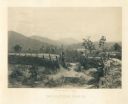
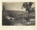
| Description: | Location of Sherman's attack at Chattanooga. There is a road, trees and shrubs in the foreground, overlooking a valley. Mountains are in the distance. P... |
| Date: | 1866 |
|---|---|
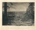
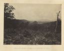
| Description: | View from Mission Ridge of the valley floor where fighting took place. Plate 10 |

| Date: | 1864 |
|---|---|
| Description: | (U.S. 39th Cong. 1stt Sess. Report of Chief engineer) The legend in the upper left corner contains a brief resume of each day's action while the map sho... |

| Date: | 1864 |
|---|---|
| Description: | This map of the Battle of Gettysburg indicates Union positions in red and Confederate positions in blue. Also shown are artillery positions, roads, railroa... |

| Date: | 1861 |
|---|---|
| Description: | This map was reproduced photographically and issued in Augusta, Ga., in the early days of the Civil War. It includes panels showing Virginia, Maryland, the... |

| Date: | 1861 |
|---|---|
| Description: | This map shows Manassas during the First Battle of Bull Run, in which the 2nd Wisconsin Infantry fought, and the Leesburg area, the site of the Battle of B... |
If you didn't find the material you searched for, our Library Reference Staff can help.
Call our reference desk at 608-264-6535 or email us at: