Filter: Categories of Wisconsin Historical Images
Filter: Subject of Battlefields
Filter: Creator Name of Unknown
Filter: Subject of transportation
Filter: Categories of Wisconsin Historical Images
Filter: Subject of Battlefields
Filter: Creator Name of Unknown
Filter: Subject of transportation
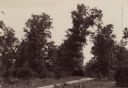
| Date: | 1890 |
|---|---|
| Description: | Site of the Battle to Antietam, The Dunker Church. A group of men stand among trees on the left. Horse-drawn carriages are under trees on the right. |
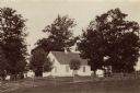
| Date: | 1890 |
|---|---|
| Description: | Hagerstown Pike. A brick wall and trees are along the road on the right. |
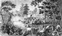
| Date: | |
|---|---|
| Description: | Steel engraving of the first major battle of the Civil War, fought in Virginia, near the Manassas, Virginia, railway junction, after which the battle is ca... |
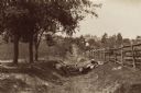
| Date: | 1890 |
|---|---|
| Description: | Site of the Battle of Antietam. The bloody lane. |
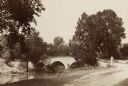
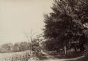
| Date: | 1890 |
|---|---|
| Description: | Site of the Battle of Antietam, the Burnside Bridge. |
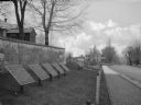
| Date: | |
|---|---|
| Description: | A view of eight commemorative tablets at the North Cemetery of Antietam Battlefield, the site of the bloodiest one-day battle in United States history in 1... |

| Date: | |
|---|---|
| Description: | Pen and ink tracing showing the positions of Union and Confederate soldiers, troop camps, location of graves, roads, drainage, vegetation, houses, and fenc... |

| Date: | 1915 |
|---|---|
| Description: | This 1915 map covers portions of Barron, Chippewa, and Rusk counties in Wisconsin. Shown are the township and range grid, sections, cities and villages, ra... |

| Date: | 1887 |
|---|---|
| Description: | Map of the Fox and Wisconsin Rivers to accompany Reuben Gold Thwaites' Historic Waterways. |

| Date: | 10 29 1944 |
|---|---|
| Description: | Robert Doyle stands with one foot resting on a railroad track on the border between Germany and Belgium. A sign on the right reads "Entering Germany." Behi... |

| Date: | 1918 |
|---|---|
| Description: | Poster with red text overlaying illustrations in blue. The top left illustration is of soldiers with cannons on battlefront. At the bottom right is an illu... |

| Date: | 1900 |
|---|---|
| Description: | A hand-drawn map of the battlefield of the Battle of Chickamauga. |

| Date: | 1864 |
|---|---|
| Description: | A map of Sherman's March from Atlanta, Georgia to Goldsboro, North Carolina. |
If you didn't find the material you searched for, our Library Reference Staff can help.
Call our reference desk at 608-264-6535 or email us at: