 Filter: Categories of Wisconsin Historical Images
Filter: Subject of Athletic fields
Filter: Subject of streets
Filter: Categories of Wisconsin Historical Images
Filter: Subject of Athletic fields
Filter: Subject of streets

| Date: | 1898 |
|---|---|
| Description: | University Heights from the Chemistry Building on University Avenue. View includes the University of Wisconsin-Madison football field, on the former site o... |
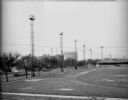
| Date: | 05 15 1931 |
|---|---|
| Description: | Breese Stevens Athletic Field, with lights on tall poles, and a chain link fence along the sidewalk. View looking toward E. Washington Avenue with Simon Br... |
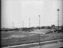
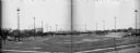
| Date: | 05 15 1931 |
|---|---|
| Description: | Breese Stevens Athletic Field with lights on tall poles, looking toward E. Mifflin Street. Houses are in the background. (Section of panorama.) |
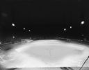
| Date: | 05 13 1931 |
|---|---|
| Description: | Elevated view of Breese Stevens Athletic Field illuminated at night. |
| Date: | 1961 |
|---|---|
| Description: | Aerial view of the Miller Electic Manufacturing Co. and surrounding area. |
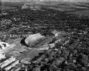
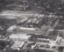
| Date: | 05 11 1951 |
|---|---|
| Description: | Aerial view of Camp Randall Stadium and Fieldhouse looking south. The photograph was taken during a ROTC annual inspection. |
| Date: | 05 15 1931 |
|---|---|
| Description: | Composite of two negatives of Breese Stevens Athletic Field with lights on tall poles. On the left, view is of the Simon Brothers Wholesale Grocery Warehou... |

| Date: | 1965 |
|---|---|
| Description: | This map shows proposed streets, arterial and collector streets, lot numbers and dimensions, parks, the disposal plant, a ball park, and school property. T... |

| Date: | 1923 |
|---|---|
| Description: | Map showing the parcel of land on the shore of Lake Monona acquired by the City of Madison for a park (today known as Olbrich Park). |

| Date: | 1968 |
|---|---|
| Description: | Air view of the University of Wisconsin-Madison campus looking north to Lake Mendota. Picnic Point, currently part of the Lakeshore Nature Preserve, and Ca... |
If you didn't find the material you searched for, our Library Reference Staff can help.
Call our reference desk at 608-264-6535 or email us at: