 Filter: Categories of Wisconsin Historical Images
Filter: Subject of Associations, institutions, etc.
Filter: Type of Map or Atlas
Filter: Subject of transportation
Filter: Categories of Wisconsin Historical Images
Filter: Subject of Associations, institutions, etc.
Filter: Type of Map or Atlas
Filter: Subject of transportation

| Date: | 1949 |
|---|---|
| Description: | Color bird's-eye map of the University of Wisconsin-Madison as it was midcentury, with two co-eds, several photographs of campus landmarks around edges, an... |
| Date: | 1925 |
|---|---|
| Description: | Booklet includes maps of Madison, Fond du Lac, Oshkosh, Appleton, Green Bay, Milwaukee, Janesville, Beloit, and La Crosse, Wisconsin and downtown Chicago a... |

| Date: | 1923 |
|---|---|
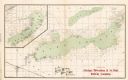
| Description: | This map from the Wisconsin Lakes and Parks Association shows the area of a proposed state park, much of which is now part of the Flambeau River State Fore... |

| Date: | 1925 |
|---|---|
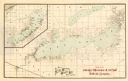
| Description: | This 1925 map of the northern portion of Sawyer County, Wisconsin, shows the township and range system, sections, roads, railroads, and lakes and streams i... |

| Date: | 1899 |
|---|---|
| Description: | These two maps of Madison and the Four Lakes region show the site of the Teachers Country Club on Lake Monona, the lakes and the Catfish or Yahara River, f... |

| Date: | 1915 |
|---|---|
| Description: | Shows land ownership, roads, railroads, and highways. Includes significant manuscript annotations and table of Wisconsin Highway Commission members. "The r... |

| Date: | 1891 |
|---|---|
| Description: | Map of a proposed subdivision. Map reads: "United States Investment Association SUBDIVISION No. 1 In S.W. 1/4 Sec. 33, Town 8, Range 22 East. Is situated a... |

| Date: | 1928 |
|---|---|
| Description: | Illustrated map of points of interest, including University buildings, parks, athletic venues, fraternity and sorority houses, and state buildings. |

| Date: | 1929 |
|---|---|
| Description: | Shows fraternities, sororities, major rooming houses, private and university buildings, and university property. Oriented with north slightly to the right. |

| Date: | 1907 |
|---|---|
| Description: | Shows public buildings, hotels, fraternity houses, and private houses. Index of fraternities and sororities, residences, public buildings, hotels, places o... |
| Date: | 1902 |
|---|---|
| Description: | A map of Lake Geneva and Lake Delavan, also including Lake Como. |
| Date: | 1907 |
|---|---|
| Description: | A map of Lake Geneva and Lake Delavan, including Lake Como. |

| Date: | 08 1902 |
|---|---|
| Description: | A detail of a Madison Sanborn map showing Mendota Court. |

| Date: | 1941 |
|---|---|
| Description: | A detail of a Sanborn map showing areas at Langdon and Henry Streets, including Lake Lawn Place. |

| Date: | 1908 |
|---|---|
| Description: | A detail of a Madison Sanborn map that includes the University of Wisconsin Boat House, UW Gymnasium & Armory (The Red Gym), fraternity houses, and the YMC... |

| Date: | 04 1905 |
|---|---|
| Description: | Map of the Madison, Wisconsin region showing the four major lakes, starting in the north with Lake Mendota, Lake Monona, Lake Waubesa, and Lake Kegonsa. La... |

| Date: | 1951 |
|---|---|
| Description: | This map shows streets, railroads, Lake Mendota, Lake Monona, Lake Wingra, golf courses, parks, Truax Field, and country clubs. Also included are street, c... |

| Date: | 1948 |
|---|---|
| Description: | This illustrated map shows major westward trails from 1785 to 1866: Old Oregon Trail and its deviations, Old Spanish Trail, Lewis and Clark route, Santa Fe... |

| Date: | 1909 |
|---|---|
| Description: | Bird's-eye view of Lake Geneva from the south extending to Waukesha and Milwaukee in the north. Delavan Lake and Lake Como are identified. Several electric... |

| Date: | 1966 |
|---|---|
| Description: | This map shows trails, roads, creeks, alleged location of George Gardner's trading post, Boulder and Mud Lakes, and a portion of the Wolf River. The map al... |
If you didn't find the material you searched for, our Library Reference Staff can help.
Call our reference desk at 608-264-6535 or email us at: