 Filter: Categories of Wisconsin Historical Images
Filter: Subject of Architecture
Filter: Year of 1800-1899
Filter: Year of 1860-1869
Filter: Categories of Wisconsin Historical Images
Filter: Subject of Architecture
Filter: Year of 1800-1899
Filter: Year of 1860-1869
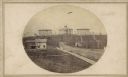
| Date: | 1865 |
|---|---|
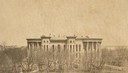
| Description: | University of Wisconsin-Madison campus showing the first three buildings on campus, South Hall (left), University Hall [Bascom Hall] (center), and North Ha... |
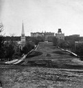
| Date: | 1868 |
|---|---|
| Description: | View from unpaved Wisconsin Avenue looking east toward the third Wisconsin State Capitol sometime prior to the completion of the dome (1869). The portion o... |
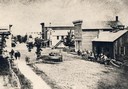
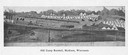
| Date: | 1860 |
|---|---|
| Description: | Elevated view of Barstow Street looking north. View from the corner of Main Street, where the Eau Claire Book and Stationary Company later stood, looking n... |
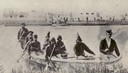
| Date: | 1860 |
|---|---|
| Description: | Nine men arrive at Fort William by canoe. Fort William, also called Kaministiguia, was the Hudson's Bay fur trading post. Men are standing along the opposi... |
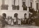
| Date: | 02 23 1867 |
|---|---|
| Description: | President Andrew Johnson and members of various Indian delegations and the White House staff pose outside the White House together. |
| Date: | 1861 |
|---|---|
| Description: | Christmas and New Years greeting card from Hosea W. Rood, presumably sent to his comrades of the 12th Wisconsin Volunteer Infantry, Company E, who had been... |
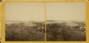
| Date: | 1868 |
|---|---|
| Description: | Stereograph of view from the Capitol looking southwest by south. In the foreground are the Capitol Park, the First Baptist Church on Carroll Street; and be... |
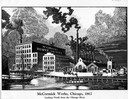
| Date: | 1867 |
|---|---|
| Description: | Engraving of the McCormick Reaper Works as it appeared in 1867. The factory was located on the north bank of the Chicago River, east of the Rush Street bri... |
| Date: | 1866 |
|---|---|
| Description: | The Third Wisconsin State Capitol before the completion of the dome. After all four wings of the Third Capitol were completed, the second Capitol was demo... |

| Date: | 1867 |
|---|---|
| Description: | Birds-eye drawing of Appleton, Outagamie Co., depicting street names and street layout, houses, the Fox River, the court house, jail, school houses, Lawren... |
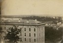
| Date: | 1861 |
|---|---|
| Description: | View of Madison from Main Hall, now Bascom Hall, on the University of Wisconsin-Madison campus. South Hall is in the foreground, with several residences an... |
| Date: | 1861 |
|---|---|
| Description: | View of Madison from Main Hall, now Bascom Hall, on the University of Wisconsin-Madison campus. South Hall is in the foreground with several residences an... |

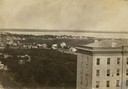
| Date: | 1861 |
|---|---|
| Description: | View of Madison from Main Hall, now Bascom Hall, on the University of Wisconsin-Madison campus looking up State Street toward the second Wisconsin State Ca... |
| Date: | 1861 |
|---|---|
| Description: | View of Madison from Main Hall, now Bascom Hall, on the University of Wisconsin-Madison campus. North Hall is in the foreground with several residences and... |
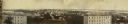
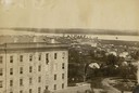
| Date: | 11 11 1861 |
|---|---|
| Description: | Panoramic view of Madison from Main Hall, now Bascom Hall, on the University of Wisconsin campus. North Hall and South Hall are in the foreground. Lake Men... |

| Date: | 1867 |
|---|---|
| Description: | Birds-eye drawing of Beaver Dam, Dodge Co., depicting street names and street layout, houses, rivers, lakes, and trees. A reference key at the bottom of th... |

| Date: | 1869 |
|---|---|
| Description: | Birds-eye drawing of Boscobel, Grant County, depicts street names and street layouts, houses, rivers and trees. A reference key at the bottom of the map sh... |

| Date: | 1868 |
|---|---|
| Description: | This 1868 birds-eye view depicts the buildings, streets, railroad, vegetation and topography of Columbus, Wisconsin. The high school, cemetery, railroad de... |

| Date: | 1867 |
|---|---|
| Description: | Birds eye drawing of Fond du Lac depicts street names and street layouts, houses, buildings, trees, and the Fond du Lac River. A reference key at the botto... |

| Date: | 1867 |
|---|---|
| Description: | Bird's-eye map of Green Bay and Fort Howard, Brown Co., depicts street names and street layouts, houses, trees, and the East River. A reference key at the ... |
If you didn't find the material you searched for, our Library Reference Staff can help.
Call our reference desk at 608-264-6535 or email us at: