 Filter: Categories of Wisconsin Historical Images
Filter: Subject of Architecture
Filter: Subject of ships
Filter: Categories of Wisconsin Historical Images
Filter: Subject of Architecture
Filter: Subject of ships

| Date: | 02 21 1882 |
|---|---|
| Description: | Chromolithograph poster advertising a Milwaukee Mardi Gras celebration, arranged by the Turnverein and Milwaukee Musical Societies, and held at the Exposit... |

| Date: | 1871 |
|---|---|
| Description: | Bird's-eye view of the Chicago fire of October 8, 1871. The hand-colored lithograph was published by Currier and Ives. |

| Date: | 1856 |
|---|---|
| Description: | View looking west from Lake Michigan with several steam ships and sailing vessels in harbor. There is a lighthouse to left of center, along shoreline. |
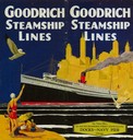
| Date: | 1930 |
|---|---|
| Description: | Cover from Goodrich Steamship Lines schedule, with a picture of a screw-driven passenger/freight vessel against the Chicago skyline and a beach scene in th... |
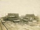
| Date: | |
|---|---|
| Description: | The Peter Grignon Shipyard next to the Marine Iron Company. |

| Date: | 1886 |
|---|---|
| Description: | Bird's-eye view of Bayfield, county seat of Bayfield County. On the lower left side is an inset for Bayfield and the Apostle Islands. |

| Date: | 1853 |
|---|---|
| Description: | Bird's-eye map of Milwaukee looking east toward Lake Michigan from a bluff, long since graded into a slope, at about 6th Street between Wisconsin Avenue an... |
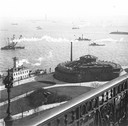
| Date: | 1900 |
|---|---|
| Description: | Elevated view, probably early 20th century New York Harbor. |
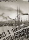
| Date: | |
|---|---|
| Description: | Elevated view of Milwaukee River from Walker's Point Bridge. |
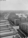
| Date: | |
|---|---|
| Description: | Milwaukee, south from Mitchell Block. View shows rooftops and building fronts. Ships and bridge are in the background on the right. |
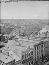
| Date: | |
|---|---|
| Description: | Milwaukee, northwest from Mitchell block. Elevated view of rooftops and buildings with River in background. |

| Date: | 1867 |
|---|---|
| Description: | Birds-eye drawing of Appleton, Outagamie Co., depicting street names and street layout, houses, the Fox River, the court house, jail, school houses, Lawren... |

| Date: | 1867 |
|---|---|
| Description: | Bird's-eye map of Green Bay and Fort Howard, Brown Co., depicts street names and street layouts, houses, trees, and the East River. A reference key at the ... |

| Date: | 1867 |
|---|---|
| Description: | Bird's-eye map of La Crosse with nine insets of residences, schools, and the Court House and Jail. |

| Date: | 1882 |
|---|---|
| Description: | Bird's-eye views of various sections of Milwaukee. |

| Date: | 1898 |
|---|---|
| Description: | Bird's-eye map of Milwaukee with prominent streets and buildings identified. Taken from City Hall Tower. |

| Date: | 1870 |
|---|---|
| Description: | Sauk City is the oldest incorporated village in Wisconsin (incorporated in 1854) and also has the oldest organized volunteer fire department in the state, ... |

| Date: | 1883 |
|---|---|
| Description: | Bird's-eye map of Superior, county seat of Douglas County, on the shores of Lake Superior, with insets of points of interest. |

| Date: | 1880 |
|---|---|
| Description: | Bird's-eye map of Waukesha, county seat of Waukesha County. |
If you didn't find the material you searched for, our Library Reference Staff can help.
Call our reference desk at 608-264-6535 or email us at:
