 Filter: Categories of Wisconsin Historical Images
Filter: Subject of Architecture
Filter: Subject of botany
Filter: Subject of surveying
Filter: Categories of Wisconsin Historical Images
Filter: Subject of Architecture
Filter: Subject of botany
Filter: Subject of surveying
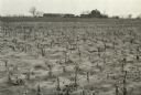
| Date: | 04 23 1937 |
|---|---|
| Description: | Sand barrens being used for poor crops. Note on back of print reads: "This should be in timber." |
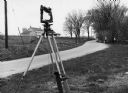
| Date: | 1970 |
|---|---|
| Description: | "Surveying Crew on McArthur Rd. Sunny Brae farm is in background." |

| Date: | 1923 |
|---|---|
| Description: | This topographical map of Devil's Lake State Park, Sauk County, Wisconsin, is based on 1922-1923 surveys of the area by the University of Wisconsin Summer ... |
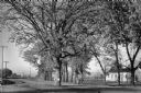
| Date: | 1955 |
|---|---|
| Description: | A large, spreading bur oak standing directly in the intersection of Hammond and Hanerville Roads, both unpaved. There is a row of smaller trees lining Hane... |
If you didn't find the material you searched for, our Library Reference Staff can help.
Call our reference desk at 608-264-6535 or email us at: