 Filter: Categories of Wisconsin Historical Images
Filter: Subject of Aquatic animals
Filter: Subject of women
Filter: Categories of Wisconsin Historical Images
Filter: Subject of Aquatic animals
Filter: Subject of women
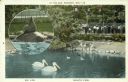
| Date: | 1940 |
|---|---|
| Description: | A postcard of the Henry Vilas Zoo (Vilas Park Zoo) depicting aquatic fowl, with an inset of a sea lion on a rock. Caption reads: "At the Zoo, Madison, Wis.... |
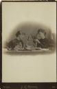
| Date: | |
|---|---|
| Description: | Cabinet card of two women sitting at a table examining a starfish and other underwater specimens using magnifiers. Open books appear on the table, probably... |
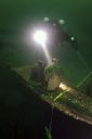
| Date: | 09 09 2008 |
|---|---|
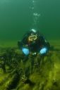
| Description: | Underwater view of a scuba diver (an underwater archaeologist) shining a light on two liquor or water jugs that had been pulled out during the archaeologic... |
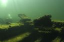
| Date: | 06 10 2005 |
|---|---|
| Description: | Underwater view of algae and mussels living on the engine mount of the sunken Louisiana. To the left, an underwater archeologist is surveying the si... |
| Date: | 06 10 2005 |
|---|---|
| Description: | Underwater view of an underwater archeologist investigating the drift pins of the Louisiana. Algae and mussels are covering most of the wood of the ... |
| Date: | 1985 |
|---|---|
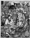
| Description: | Imaginative pen-and-ink drawing that appeared in the Capitol Times May 3, 1985 with Sid's caption: "Charlie Lunker Bass is down at the rustic barber... |

| Date: | 1636 |
|---|---|
| Description: | Map of North America, divided into regions, and showing some rivers, lakes, settlements, cities, mountains, and Native American land. Of the Great Lakes on... |

| Date: | 1740 |
|---|---|
| Description: | Map including the regions and cities of the northern half of North America. Native American land, rivers, lakes, mountains are labeled. Mountains, marshes,... |

| Date: | 1759 |
|---|---|
| Description: | Map of north eastern Canada and parts of New England, showing settlements, cities, portages, Native American land, mountains, lakes, and rivers. The unusua... |

| Date: | 1915 |
|---|---|
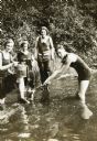
| Description: | View towards a group digging for fresh water mussels in Archibald Lake. From left to right: a woman waist-deep in the water; a boy holding onto the side of... |
| Date: | 1922 |
|---|---|
| Description: | Jeannette Holt (far left) is standing in the water near the shoreline with one foot up on a log. She is balancing a metal pail on her knee, which has a scr... |
If you didn't find the material you searched for, our Library Reference Staff can help.
Call our reference desk at 608-264-6535 or email us at: