 Filter: Categories of Wisconsin Historical Images
Filter: Subject of Apostle Islands
Filter: Subject of industries
Filter: Categories of Wisconsin Historical Images
Filter: Subject of Apostle Islands
Filter: Subject of industries

| Date: | 1886 |
|---|---|
| Description: | Bird's-eye view of Ashland, on the shores of Lake Superior, with insets of The Apostle Islands Chequamagon Bay & Ashland, and Distances from Ashland. |

| Date: | 1886 |
|---|---|
| Description: | Bird's-eye view of Bayfield, county seat of Bayfield County. On the lower left side is an inset for Bayfield and the Apostle Islands. |

| Date: | 1886 |
|---|---|
| Description: | Bird's-eye map of Washburn on Lake Superior. There is an inset of Washburn, Chequamagon and the Apostle Islands. |
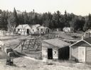
| Date: | 1950 |
|---|---|
| Description: | Elevated view of land operations of commercial fishing operation with fish net drying reels and buildings on Apostle Islands. |
| Date: | 1915 |
|---|---|
| Description: | Building, boats, and fish net drying reels on South Twin Island in the Apostle Islands archipelago. |

| Date: | 1913 |
|---|---|
| Description: | Captain Dan Angus standing on wooden boat dock, smoking a cigar. Dr. Albert Gregory Hull is partially visible on the left. The boat dock is possibly on Dev... |
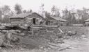
| Date: | 1910 |
|---|---|
| Description: | Madeline Island logging camp near Big Bay. Men preparing logs for a building, with three log buildings in background. |
| Date: | 1915 |
|---|---|
| Description: | Bill Baker standing on top of a wall of the quarry on Basswood Island. |

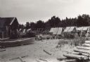
| Date: | 1910 |
|---|---|
| Description: | Logging Camp dock and buildings made of logs. Madeline Island shoreline on the bank of Lake Superior. |

| Date: | 1845 |
|---|---|
| Description: | This map shows lakes, rivers, Chippewa land, the U.S. Mineral Land Agency, boundary between U.S. and Canada, Methodist and Catholic missions, and American ... |

| Date: | 1871 |
|---|---|
| Description: | This map shows railroads, canals, towns and some lighthouses. Areas of the company lands proper, tin, iron, gold & silver, silver islet, and lead are color... |
If you didn't find the material you searched for, our Library Reference Staff can help.
Call our reference desk at 608-264-6535 or email us at: