 Filter: Categories of Wisconsin Historical Images
Filter: Subject of Apostle Islands
Filter: County of Bayfield
Filter: Categories of Wisconsin Historical Images
Filter: Subject of Apostle Islands
Filter: County of Bayfield
| Date: | |
|---|---|
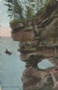
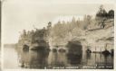
| Description: | Colorized postcard of a port hole through the north cape or point of Presque Isle or Stockton Island, part of the Apostle Islands. A person in a boat is ou... |
| Date: | |
|---|---|
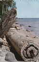
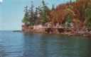
| Description: | Color postcard of rocks and driftwood along Rocky Island's shoreline, part of the Apostle Islands. |
| Date: | |
|---|---|
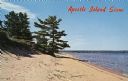
| Description: | Color postcard of a sandy shoreline on one of the Apostle Islands. Caption reads: "Apostle Island Scene." |
| Date: | |
|---|---|
| Description: | Photographic postcard of a scene from the Apostle Island Indian Pageant. A large group of young children in white shirts are sitting along a sloped hill ne... |
| Date: | |
|---|---|
| Description: | Color postcard of a rocky shoreline on Devil's Island, part of the Apostle Islands of Lake Superior. |
| Date: | |
|---|---|
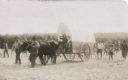
| Description: | Photographic postcard of a scene from the Apostle Island Indian Pageant. Two children are sitting aboard a covered wagon pulled by a pair of steers while t... |
| Date: | 1885 |
|---|---|
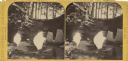
| Description: | Stereograph of a sailboat in Excursion Cave, on Hemlock Island of the Apostle Islands. A man can be seen sitting in the boat. |
| Date: | 1932 |
|---|---|
| Description: | Lake view of Apostle Islands sandstone caves along the shores of Lake Superior. |

| Date: | 1880 |
|---|---|
| Description: | This copy of an 1834 map in the American Fur Company's papers held by the New-York Historical Society shows an outline of Chequamegon Bay and Madeline Isla... |

| Date: | 1871 |
|---|---|
| Description: | Asaph Whittlesey arrived in Ashland in 1854, one of the earliest of the settlers who hoped the area would grow and make their fortunes. He drew this map of... |

| Date: | 1871 |
|---|---|
| Description: | Asaph Whittlesey arrived in Ashland in 1854, one of the earliest of the settlers who hoped the area would grow and make their fortunes. He drew this map of... |

| Date: | |
|---|---|
| Description: | Exterior of the menu for Paul's Cafe, with a bird's-eye view map of "Washburn's Natural Deep Water Land Locked Harbor," Chequamegon Bay, and the Apostle Is... |

| Date: | 07 2001 |
|---|---|
| Description: | David Obey poses with Park Ranger Geoffrey Smith on the left and Martin Hanson on the right. They are standing on the beach with water and land in the back... |

| Date: | 1979 |
|---|---|
| Description: | David and Joan Obey (right) with Senator Gaylord Nelson (2nd from left) and Secretary of the Interior Cecil Andrus (on Nelson's left) on an Apostle Islands... |

| Date: | |
|---|---|
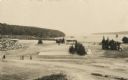
| Description: | Three women stand on the shore in front of the steamer Barker at Devils Island natural dock. |
If you didn't find the material you searched for, our Library Reference Staff can help.
Call our reference desk at 608-264-6535 or email us at: