 Filter: Categories of Wisconsin Historical Images
Filter: Subject of Agriculture
Filter: Subject of ships
Filter: Subject of islands
Filter: Categories of Wisconsin Historical Images
Filter: Subject of Agriculture
Filter: Subject of ships
Filter: Subject of islands
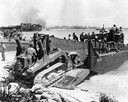
| Date: | 1944 |
|---|---|
| Description: | U.S. Marines using an International TD-9 diesel TracTracTor (crawler tractor) with a Bucyrus Erie shovel on an LCM (Landing Craft, Materiel) at Roi during ... |

| Date: | 1874 |
|---|---|
| Description: | Bird's-eye map of Chippewa Falls. |
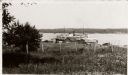
| Date: | 1925 |
|---|---|
| Description: | Washington Island, including field and fence, with buildings, automobiles, and a large ship in the distance. |

| Date: | 1945 |
|---|---|
| Description: | Marines use an International TD-9 crawler tractor (TracTracTor) and dozer shovel loader to unload supplies on a beach. A ship is in the background. The ori... |

| Date: | 1945 |
|---|---|
| Description: | Marines use an International TD-9 crawler tractor (TracTracTor) with a dozer shovel loader to fill a truck parked on a beach. A ship is in the water behind... |

| Date: | 03 1777 |
|---|---|
| Description: | Map showing the British and Hessian attack on Fort Washington in November of 1776. The movements and fortifications of the British and Hessian troops appea... |

| Date: | 1755 |
|---|---|
| Description: | Map of Virginia and parts of Maryland, North Carolina, and New Jersey. It shows borders, boundary lines, some Native American land, counties, cities, towns... |
If you didn't find the material you searched for, our Library Reference Staff can help.
Call our reference desk at 608-264-6535 or email us at: