 Filter: Categories of Wisconsin Historical Images
Filter: Subject of Agriculture
Filter: Subject of mounds
Filter: Categories of Wisconsin Historical Images
Filter: Subject of Agriculture
Filter: Subject of mounds
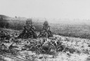
| Date: | 1890 |
|---|---|
| Description: | At the Aztalan Indian Mounds a group of people are standing on a hillside in the background. In the foreground are corn shocks. |
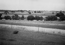
| Date: | 1945 |
|---|---|
| Description: | Field prior to the park's reconstruction, with a fence in the foreground. A river is at the bottom of the hill. |
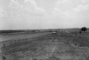
| Date: | |
|---|---|
| Description: | View of Aztalan State Park site when it was called Aztalan Mound Park. |

| Date: | 1910 |
|---|---|
| Description: | A sightseeing party wanders among cows and Native American burial mounds near the popular picnic area at Merrill Springs, on the south shore of Lake Mendot... |

| Date: | 1872 |
|---|---|
| Description: | This map, which includes eastern Iowa, northern Illinois and a portion of Michigan's Upper peninsula, shows the township survey grid and identifies countie... |

| Date: | 1927 |
|---|---|
| Description: | Three men and two women sit on top of a mound near Trade Lake. |

| Date: | 1873 |
|---|---|
| Description: | A map of the township of Primrose from the "Atlas of Dane County." |

| Date: | 1925 |
|---|---|
| Description: | This map shows trails, mounds, villages, corn fields, and contemporary civil townships; some villages and features include both Indian and English place na... |

| Date: | 1930 |
|---|---|
| Description: | Poppies are blooming in a large field with a hill in the background. The photographer identifies the hill as a shell mound. The shell mound is likely the l... |
If you didn't find the material you searched for, our Library Reference Staff can help.
Call our reference desk at 608-264-6535 or email us at: