Filter: Categories of Wisconsin Historical Images
Filter: Subject of Agriculture
Filter: Subject of mississippi river
Filter: Categories of Wisconsin Historical Images
Filter: Subject of Agriculture
Filter: Subject of mississippi river

| Date: | 1884 |
|---|---|
| Description: | Bird's-eye view drawing of the grounds of Villa Louis, the estate of the fur trading Dousman family. After the death of H. Louis Dousman's mother in 1882, ... |

| Date: | 1900 |
|---|---|
| Description: | Elevated view of the brewery dwarfed by the overhead bluffs. The brewery was built by William Schmitz. George Scheibl ran the brewery from 1899 until his d... |

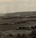
| Date: | |
|---|---|
| Description: | Elevated view from bluff of a house in Cassville surrounded by bluffs, trees and farmland. Railroad tracks run between the crops and the trees, and the Mis... |

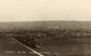
| Date: | 1900 |
|---|---|
| Description: | Elevated view of La Crosse. Caption reads: "Panorama of La Crosse, Wis. from Grand Dad's Bluff." |
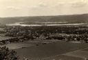
| Date: | 1910 |
|---|---|
| Description: | Elevated view from Brisbois Bluff of town, Mississippi River, and hills beyond. |
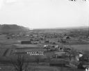
| Date: | 1930 |
|---|---|
| Description: | Elevated view of the north side of town, from high on the bluff. Caption reads: "'Birdseye' No. End Prairie Du Chien, Wis." |

| Date: | |
|---|---|
| Description: | Memohead of the G. Heileman Brewing Company of La Crosse, Wisconsin, manufacturers of keg and bottled beer, with an elevated view of the brewery complex, i... |

| Date: | |
|---|---|
| Description: | Letterhead of the John Gund Brewing Company of La Crosse, Wisconsin, with an elevated view of the brewery complex on the left. On the right is the company ... |

| Date: | 1872 |
|---|---|
| Description: | This map, which includes eastern Iowa, northern Illinois and a portion of Michigan's Upper peninsula, shows the township survey grid and identifies countie... |

| Date: | 1902 |
|---|---|
| Description: | This map shows the railroads of southern Wisconsin with the routes of the Chicago, Milwaukee, and St. Paul Railway traced in red. The township grid, counti... |

| Date: | 1906 |
|---|---|
| Description: | A commercial map of Wisconsin showing the location of creameries and cheese factories in the state. In the lower portion of the map provides the number of ... |
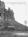
| Date: | 1905 |
|---|---|
| Description: | Large rock formation with farm outbuildings, and what appears to be railroad tracks at the base. The Mississippi River is in the foreground. Crop on image ... |

| Date: | 1900 |
|---|---|
| Description: | Elevated view over city. A church is in the middle foreground, and the Mississippi River and far shoreline is in the background. On the right side is a dir... |

| Date: | 1904 |
|---|---|
| Description: | Panoramic view of Governor Nelson Dewey's estate. The left image is of an old stone barn with a shed in the rear. The center image is another barn. The rig... |

| Date: | |
|---|---|
| Description: | View over town, including hotel and church, towards the Mississippi River. The far shoreline and bluffs are in the distance. |

| Date: | |
|---|---|
| Description: | Elevated view of Cassville, including the town hall and St. Peter's Church. |
| Date: | |
|---|---|
| Description: | View down hill towards Stoddard, with the Mississippi River and hills in the background. The German Lutheran Church is in the foreground, and there are rai... |
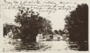
| Date: | |
|---|---|
| Description: | Hives on top of a shed in a flood. From Mr. J.D. Shields, Natchez, Mississippi. A part of his Louisiana apiary placed on a shed to prevent their being swep... |
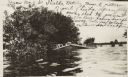
| Date: | |
|---|---|
| Description: | View across water of beehives on top of a shed in a flood. Writing on photograph: "From Mr. J.D. Shields, Natchez, Mississippi. A picture of part of his Lo... |
If you didn't find the material you searched for, our Library Reference Staff can help.
Call our reference desk at 608-264-6535 or email us at: