 Filter: Categories of Wisconsin Historical Images
Filter: Subject of Agriculture
Filter: Subject of michigan, lake
Filter: Subject of industries
Filter: Categories of Wisconsin Historical Images
Filter: Subject of Agriculture
Filter: Subject of michigan, lake
Filter: Subject of industries
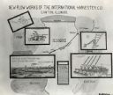
| Date: | 1919 |
|---|---|
| Description: | Chart or sign illustrating the "New Plow Works of the International Harvester Co. Canton, Illinois." The middle of the poster features an article titled "H... |

| Date: | 1872 |
|---|---|
| Description: | This map, which includes eastern Iowa, northern Illinois and a portion of Michigan's Upper peninsula, shows the township survey grid and identifies countie... |
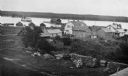
| Date: | 1915 |
|---|---|
| Description: | Elevated view of Fish Creek Harbor as a boat approaches the pier and warehouse. In the foreground are houses with outbuildings, gardens and a small orchard... |

| Date: | |
|---|---|
| Description: | Aerial view of harbors and bridge. Farm fields are on either side of the bridge. The city of Sturgeon Bay is in the distance. There are docks along the sho... |

| Date: | 1937 |
|---|---|
| Description: | Pictorial map showing historical events and locations within the state of Wisconsin, as well as waterways and counties. Original caption on the bottom marg... |
If you didn't find the material you searched for, our Library Reference Staff can help.
Call our reference desk at 608-264-6535 or email us at: